Category:'t Binnenhuis (Amsterdam)
Jump to navigation
Jump to search

| Object location | | View all coordinates using: OpenStreetMap - Google Earth - Proximityrama |
|---|
 | |||||
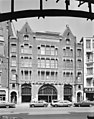
| Location | Amsterdam, North Holland, Netherlands | ||||
| Located at street address |
| ||||
| Heritage designation |
| ||||
| |||||
|
|
|||||
|
This is a category about rijksmonument number 518375 |
Address
| Raadhuisstraat 46-50 Amsterdam Netherlands |
Media in category "'t Binnenhuis (Amsterdam)"
The following 2 files are in this category, out of 2 total.
 T' Binnenhuis, Raadhuisstraat 46.JPG 2,304 × 3,072; 1.59 MB
 Voorgevel - Amsterdam - 20020331 - RCE.jpg 946 × 1,200; 225 KB
