Category:'t Keerhoes, Cadier en Keer
Jump to navigation
Jump to search

| Object location | | View all coordinates using: OpenStreetMap - Google Earth - Proximityrama |
|---|
.JPG) | |||||
| Location | Eijsden-Margraten, Limburg, Netherlands | ||||
| Located at street address |
| ||||
| Heritage designation |
| ||||
| |||||
|
|
|||||
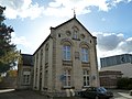
Nederlands: Raadhuis Annex Lagere School, Het Keerhoes
|
This is a category about rijksmonument number 491748 |
Address
| Limburgerstraat 78 6267 CG Cadier en Keer Netherlands |
Media in category "'t Keerhoes, Cadier en Keer"
The following 4 files are in this category, out of 4 total.
 Cadier en Keer-Limburgerstraat 78 (1).JPG 4,000 × 3,000; 4.8 MB
 Cadier en Keer-Limburgerstraat 78 (2).JPG 4,000 × 3,000; 4.78 MB
 Overzicht - Cadier en Keer - 20046363 - RCE.jpg 788 × 1,200; 194 KB
 Overzicht voorgevel en linker zijgevel - Cadier en Keer - 20355762 - RCE.jpg 1,179 × 1,200; 306 KB
.JPG)

