Category:'t Woudt 23, Schipluiden
Jump to navigation
Jump to search

| Object location | | View all coordinates using: OpenStreetMap - Google Earth - Proximityrama |
|---|
 | |||||
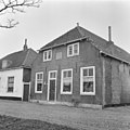
| Instance of | school building | ||||
| Location | Midden-Delfland, South Holland, Netherlands | ||||
| Located at street address |
| ||||
| Heritage designation |
| ||||
| |||||
|
|
|||||
|
This is a category about rijksmonument number 33393 |
Address
| 't Woudt 23 Schipluiden Netherlands |
Media in category "'t Woudt 23, Schipluiden"
The following 3 files are in this category, out of 3 total.
 Dorpsgezicht - 't Woudt - 20218222 - RCE.jpg 1,191 × 1,200; 415 KB
 Schoolhuis (1772), voorgevel - 't Woudt - 20218292 - RCE.jpg 1,199 × 1,200; 326 KB
 Woudt23.jpg 2,736 × 3,648; 6.44 MB

,_voorgevel_-_%27t_Woudt_-_20218292_-_RCE.jpg)