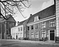
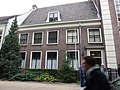
Category:'t Zand 31, Amersfoort
Jump to navigation
Jump to search

| Object location | | View all coordinates using: OpenStreetMap - Google Earth - Proximityrama |
|---|
 | |||||
| Instance of | clergy house | ||||
| Location | Amersfoort, Utrecht, Netherlands | ||||
| Located at street address |
| ||||
| Heritage designation |
| ||||
| |||||
|
|
|||||
|
This is a category about rijksmonument number 8080 |
Address
| 't Zand 31 Amersfoort Netherlands |
Media in category "'t Zand 31, Amersfoort"
The following 7 files are in this category, out of 7 total.
 Achterzijde - Amersfoort - 20010429 - RCE.jpg 1,200 × 960; 318 KB
 Overzicht - Amersfoort - 20010434 - RCE.jpg 1,200 × 953; 310 KB
 Plafond - Amersfoort - 20010431 - RCE.jpg 1,200 × 1,198; 199 KB
 Plafond - Amersfoort - 20010432 - RCE.jpg 1,197 × 1,200; 298 KB
 RM8080 t Zand 31.JPG 4,320 × 3,240; 2.37 MB
 Voorgevel - Amersfoort - 20010428 - RCE.jpg 1,200 × 960; 315 KB
 Voorgevel - Amersfoort - 20010435 - RCE.jpg 1,200 × 960; 296 KB


