Category:"Ausgestochene Marter" wayside shrine
Jump to navigation
Jump to search

| Object location | | View all coordinates using: OpenStreetMap - Google Earth - Proximityrama |
|---|
This is the category of the Bavarian Baudenkmal (cultural heritage monument) with the ID D-6-75-155-29
|
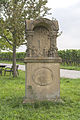
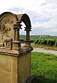
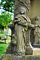
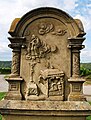
Deutsch: Bildstock, wird im Volksmund „ausgestochene Marter“ genannt. Errichtet wurde er im Jahr 1719 von Johann Marquard. Die Marter hat die Form eines Prozessionsaltars. Vier Säulen tragen einen Baldachin. Hinten ein steinerner Abschluss mit der Darstellung der Kreuzigung.
.
| Instance of | architectural structure | ||||
| Location | |||||
| Heritage designation | |||||
| |||||
|
|
|||||
Media in category ""Ausgestochene Marter" wayside shrine"
The following 11 files are in this category, out of 11 total.
 Altarbildstock D-6-75-155-29 01.jpg 2,222 × 3,333; 1.3 MB
 Altarbildstock D-6-75-155-29 02.jpg 2,222 × 3,333; 1.6 MB
 Altarbildstock, Nordheim.JPG 2,592 × 3,872; 4.33 MB
 Altarbildstock, Vogelsburg, Nordheim.JPG 2,416 × 3,511; 3.22 MB
 Detail 1, links vorne, Altarbildstock, Nordheim.JPG 2,592 × 3,872; 3.85 MB
 Detail 2, rechts vorne, Altarbildstock, Nordheim.JPG 2,592 × 3,734; 3.45 MB
 Detail 3, rechts hinten, Altarbildstock, Nordheim.JPG 2,507 × 3,688; 3.71 MB
 Detail 4, links hinten, Altarbildstock, Nordheim.JPG 2,448 × 3,872; 3.88 MB
 Inschrift, Altarbildstock, Nordheim.JPG 3,070 × 2,583; 4.14 MB
 Kreuzigung, Altarbildstock, Nordheim.JPG 2,434 × 3,701; 3.34 MB
 Rückseite, Altarbildstock, Nordheim.JPG 2,592 × 3,426; 3.88 MB


