File:Cottus gobio (in situ).jpg
Jump to navigation
Jump to search


Size of this preview: 800 × 600 pixels. Other resolutions: 320 × 240 pixels | 640 × 480 pixels | 1,024 × 768 pixels | 1,280 × 960 pixels | 2,400 × 1,800 pixels.
Original file (2,400 × 1,800 pixels, file size: 4.04 MB, MIME type: image/jpeg)
.jpg)
| Camera location | | View this and other nearby images on: OpenStreetMap - Google Earth |
|---|
.jpg¶ms=050.076556_N_0004.580028_E_globe:Earth_type:camera_&language=en)
| Description |
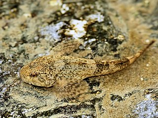
Cottus gobio Linnaeus, 1758 Deutsch: Groppe
English: European bullhead in the Viroin close to Nismes.
Français : Chabot commun. Photo prise dans le Viroin, près de Nismes.
Nederlands: Cottus gobio
Polski: Głowacz białopłetwy |
|||||
| Date | ||||||
| Photographer | Hans Hillewaert | |||||
| Source | Own work | |||||
| Permission (Reusing this file) |
|
|||||
| Other licenses | More (4100+) and new images on : High resolution files on request. . |
|||||
| Attribution (required by the license) |
© Hans Hillewaert / | |||||

|
This image has been assessed under the valued image criteria and is considered the most valued image on Commons within the scope: Cottus gobio (European bullhead). You can see its nomination here. |
.jpg)
File history
Click on a date/time to view the file as it appeared at that time.
| Date/Time | Thumbnail | Dimensions | User | Comment | |
|---|---|---|---|---|---|
| current | 07:11, 28 June 2011 | | 2,400 × 1,800 (4.04 MB) | Biopics (talk | contribs) | levels & wb |
| 07:35, 5 June 2009 |  | 2,400 × 1,800 (1,013 KB) | Lycaon (talk | contribs) | {{Location|50|4|35.60|N|4|34|48.10|E}} {{Information |Description= ''Cottus gobio'' Linnaeus, 1758 {{en|European bullhead in the Eau Noire close to Nismes}} |Source= {{own}} |Date= 2009-06-01 |Author= Hans Hillewaert |Permission= {{se |
- You cannot overwrite this file.
File usage on Commons
The following 8 pages uses this file:
File usage on other wikis
The following other wikis use this file:
- Usage on als.wikipedia.org
- Usage on ar.wikipedia.org
- Usage on ba.wikipedia.org
- Usage on be.wikipedia.org
- Usage on bg.wikipedia.org
- Usage on ca.wikipedia.org
- Usage on ceb.wikipedia.org
- Usage on cs.wikipedia.org
- Usage on cy.wikipedia.org
- Usage on de.wikipedia.org
- Rheingroppe
- Böhmerwald-Mühltäler (Europaschutzgebiet)
- Bodenseeuferlandschaft östlich Friedrichshafen
- Untere Argen und Seitentäler
- Rotachtal Bodensee
- Bodenseeufer westlich Friedrichshafen
- Bodensee Hinterland bei Überlingen
- Cottus
- Zwettltal
- Donau zwischen Riedlingen und Sigmaringen
- Wurzacher Ried und Rohrsee
- Riede und Gewässer bei Mengen und Pfullendorf
- Gebiete um das Laucherttal
- Oberes Donautal zwischen Beuron und Sigmaringen
- Schmeietal
- Liste von Fischen und Rundmäulern in Nordrhein-Westfalen
- Neckar und Seitentäler bei Rottenburg
- Gebiete zwischen Bisingen, Haigerloch und Rosenfeld
- Rot, Bellamonter Rottum und Dürnach
- Umlachtal und Riß südlich Biberach
- Donau zwischen Munderkingen und Ulm und nördliche Iller
- Aitrach, Ach und Dürrenbach
- Donau zwischen Munderkingen und Riedlingen
- Großer Heuberg und Donautal
- Östlicher Großer Heuberg
- Spitzberg, Pfaffenberg, Kochhartgraben und Neckar
- Schönbuch (FFH-Gebiet)
- Adelegg (FFH-Gebiet)
- Argen und Feuchtgebiete bei Neukirch und Langnau
- Neckartal zwischen Rottweil und Sulz
- Prim-Albvorland
View more global usage of this file.
.jpg)
.jpg&oldid=173048788)
.jpg)
.jpg&action=edit)
.jpg&action=history)
.jpg)
.jpg)
.jpg&oldid=173048788)
.jpg&action=info)
.jpg&mobileaction=toggle_view_mobile)