File:Cte cachamay aereo.jpg
Jump to navigation
Jump to search


Size of this preview: 800 × 512 pixels. Other resolutions: 320 × 205 pixels | 640 × 410 pixels | 1,024 × 655 pixels | 1,280 × 819 pixels | 1,600 × 1,024 pixels.
Original file (1,600 × 1,024 pixels, file size: 464 KB, MIME type: image/jpeg)
Summary[edit]
| Description |
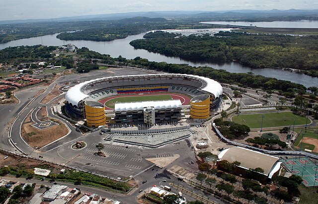
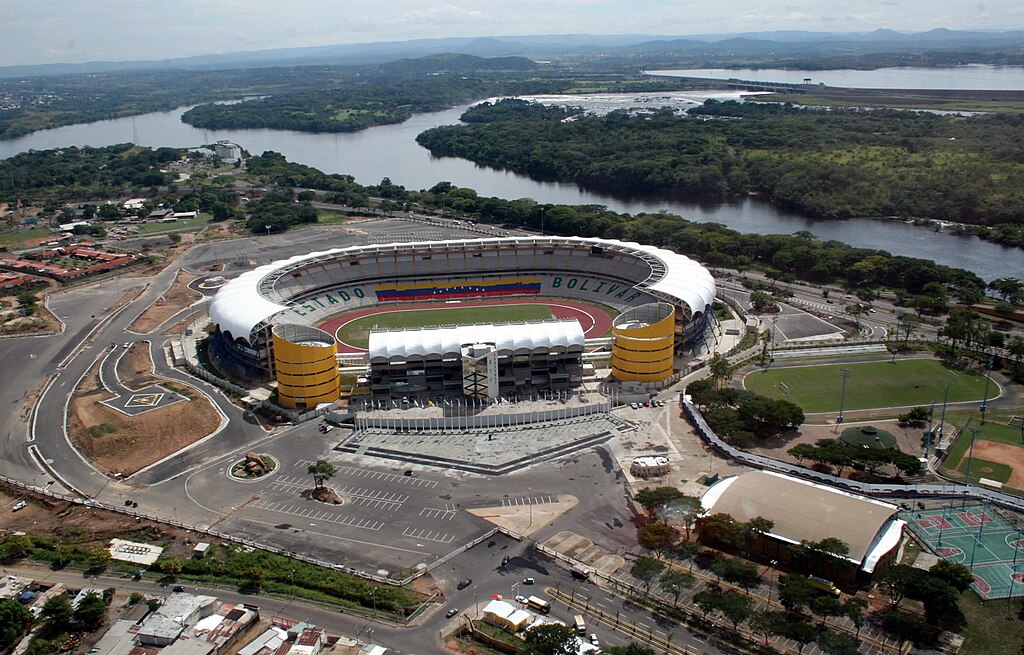
English: Aerial loca view of CTE Cachamay (center), Following clockwise: the alternating field (Cachamaicito), the softball field, basketball courts and the Hermanas González Gym. At the background is La Llovizna Park, Macagua Power Station and the Cachamay Park.
Español: Vista Aérea del CTE Cachamay (centro), siguiendo el sentido de las agujas del reloj, se ubica el campo alterno (Cachamaicito), la cancha de sóftbol, baloncesto y el gimnasio Hermanas González. En el fondo se observa al Parque La Llovizna, la Central Hidroeléctrica Macagua y el Parque Cachamay.
Français : Vue aérienne sur le centre sportif CTE Cachamay. Dans le sens d'une aiguille du monde : le terrein de Cachamaicito, le terrain de softball, le centre de basket et le gymnase Hermanas González. En arrière-plan, les parcs de La Llovizna et de Cachamay, et la centrale hydroélectrique de Macagua.
|
| Date | |
| Source | Own work |
| Author | Shaolingv4 |
| Camera location | | View this and other nearby images on: OpenStreetMap - Google Earth |
|---|
Licensing[edit]
I, the copyright holder of this work, hereby publish it under the following licenses:

|
Permission is granted to copy, distribute and/or modify this document under the terms of the GNU Free Documentation License, Version 1.2 or any later version published by the Free Software Foundation; with no Invariant Sections, no Front-Cover Texts, and no Back-Cover Texts. A copy of the license is included in the section entitled GNU Free Documentation License. |
|
This file is licensed under the Creative Commons Attribution-Share Alike 4.0 International, 3.0 Unported, 2.5 Generic, 2.0 Generic and 1.0 Generic license. | |
|
You may select the license of your choice.

|
This image has been assessed under the valued image criteria and is considered the most valued image on Commons within the scope: Polideportivo Cachamay Stadium, Guayana City (general view). You can see its nomination here. |
File history
Click on a date/time to view the file as it appeared at that time.
| Date/Time | Thumbnail | Dimensions | User | Comment | |
|---|---|---|---|---|---|
| current | 18:19, 24 March 2008 | | 1,600 × 1,024 (464 KB) | Shaolingv4~commonswiki (talk | contribs) | {{Information |Description= Vista Aérea del CTE Cachamay // Aerial view of CTE Cachamay |Source=self-made |Date=2007-10-18 |Author= Shaolingv4 |Permission= |other_versions= }} |
- You cannot overwrite this file.
File usage on Commons
The following 5 pages uses this file:
File usage on other wikis
The following other wikis use this file:
- Usage on ar.wikipedia.org
- Usage on ast.wikipedia.org
- Usage on de.wikipedia.org
- Usage on en.wikipedia.org
- Usage on es.wikipedia.org
- Usage on fi.wikipedia.org
- Usage on fr.wikipedia.org
- Usage on hr.wikipedia.org
- Usage on it.wikipedia.org
- Usage on ka.wikipedia.org
- Usage on nl.wikipedia.org
- Usage on pt.wikipedia.org
- Usage on ru.wikipedia.org
- Usage on sh.wikipedia.org
- Usage on sr.wikipedia.org
- Usage on sv.wikipedia.org
- Usage on tr.wikipedia.org
- Usage on uk.wikipedia.org
- Usage on www.wikidata.org
- Usage on zh.wikipedia.org