File:Dead Sea salt formation (Aerial view, 2007).jpg
Jump to navigation
Jump to search


Size of this preview: 800 × 531 pixels. Other resolutions: 320 × 213 pixels | 640 × 425 pixels | 1,024 × 680 pixels | 1,280 × 850 pixels | 4,288 × 2,848 pixels.
Original file (4,288 × 2,848 pixels, file size: 8.59 MB, MIME type: image/jpeg)
Summary[edit]
.jpg&action=edit§ion=1)
| Description |
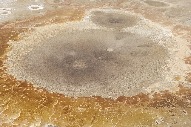
English: Crater-like salt formation near the Dead Sea surface shot from a helicopter at approximately 400 feet (120m).
עברית: תצורת מלח דמוית מכתש ליד ים המלח. צולם ממסוק בגובה 120 מטר (400 רגל) בערך.
|
| Date | |
| Source | Own work |
| Author | Godot13 |
| Permission (Reusing this file) |
Use outside of Wikipedia must attribute photo credit to Andrew Shiva |
| Attribution (required by the license) |
Andrew Shiva / Wikipedia / |
| This image was selected as picture of the day on Wikimedia Commons for . It was captioned as follows: English: Crater-like salt formation on the Dead Sea surface shot from a helicopter at approximately 400 feet (120m). Deutsch: Salzformation am Toten Meer English: Crater-like salt formation on the Dead Sea surface shot from a helicopter at approximately 400 feet (120m). Italiano: Formazione salina simile a un cratere sulla superficie del Mar Morto fotografata da un elicottero a circa 120 metri d'altezza. Magyar: Körülbelül 120 méteres magasságból egy helikopterről fényképezett kráterforma sóképződmény a Holt-tengerben Nederlands: Een kratervormige zoutformatie aan het oppervlak van de Dode Zee genomen vanuit een helikopter op ongeveer 120 meter. Svenska: En kraterliknande saltformation på Döda havets yta fotograferad från 120 meters höjd. |
|
.jpg)
.jpg)
.jpg)
| Camera location | | View this and other nearby images on: OpenStreetMap - Google Earth |
|---|
.jpg¶ms=031.363605_N_0035.429521_E_globe:Earth_type:camera_&language=en)
| Camera Model | NIKON DX2s |
|---|---|
| Mode | Manual (M) |
| Shutter speed | 1/1500 |
| Aperture | f/3.8 |
| Film speed (ISO) | 100 |
| Focal length | 28 mm |
| Focal length (35 mm equiv.) | 42 |
Licensing[edit]
.jpg&action=edit§ion=2)
I, the copyright holder of this work, hereby publish it under the following license:
|
This file is licensed under the Creative Commons Attribution-Share Alike 4.0 International license. | |
|

|
The copyright holder of this file, Andrew Shiva, allows anyone to use it for any purpose, provided that the copyright holder is properly attributed. Redistribution, derivative work, commercial use, and all other use is permitted. |
| Attribution: Use or reproduction of this image outside of Wikipedia must give the original photographer (Andrew Shiva) credit. Although not required, it would be appreciated if a message was left here indicating where this image was being used.
|
|

|
This image has been assessed under the valued image criteria and is considered the most valued image on Commons within the scope: Aerial photographs of Dead Sea salt formations. You can see its nomination here. |
File history
Click on a date/time to view the file as it appeared at that time.
| Date/Time | Thumbnail | Dimensions | User | Comment | |
|---|---|---|---|---|---|
| current | 09:09, 17 January 2013 | | 4,288 × 2,848 (8.59 MB) | Godot13 (talk | contribs) | CA correction |
| 06:32, 15 January 2013 |  | 4,288 × 2,848 (8.08 MB) | Godot13 (talk | contribs) | User created page with UploadWizard |
- You cannot overwrite this file.
File usage on Commons
The following 40 pages uses this file:
- Israel
- User:Godot13/Gallery
- User:Godot13/Gallery/Countries/Israel
- User:Godot13/Sandbox2
- User:Godot13/Waiting for Godot
- User:Miya/sandbox/FP/2013/Galleries/Table
- User:Zyephyrus/2014
- User:Zyephyrus/2014/1
- User talk:Godot13/Archive1
- User talk:Godot13/Archive3
- Commons:Featured picture candidates/File:Dead Sea salt formation (Aerial view, 2007).jpg
- Commons:Featured picture candidates/Log/January 2013
- Commons:Featured pictures/Places/Natural
- Commons:Featured pictures/chronological/2013-A
- Commons:Picture of the Year/2013/Candidates
- Commons:Picture of the Year/2013/Galleries/Table
- Commons:Picture of the Year/2013/R1/Gallery/2013-A
- Commons:Picture of the Year/2013/R1/Gallery/ALL
- Commons:Picture of the Year/2013/R1/Gallery/M01
- Commons:Picture of the Year/2013/R1/Gallery/Nature views
- Commons:Picture of the Year/2013/R1/Results/Candidates
- Commons:Picture of the Year/2013/R1/v/Dead Sea salt formation (Aerial view, 2007).jpg
- Commons:Quality images/Subject/Places/Natural structures
- Commons:Quality images candidates/Archives January 2013
- Commons:Valued image candidates/Dead Sea salt formation (Aerial view, 2007).jpg
- Commons:Valued images by topic
- Commons:Valued images by topic/Natural phenomena
- Template:Potd/2013-02
- Template:Potd/2013-02-21
- Template:Potd/2013-02-21 (de)
- Template:Potd/2013-02-21 (en)
- Template:Potd/2013-02-21 (hu)
- Template:Potd/2013-02-21 (it)
- Template:Potd/2013-02-21 (ja)
- Template:Potd/2013-02-21 (ka)
- Template:Potd/2013-02-21 (ko)
- Template:Potd/2013-02-21 (nl)
- Template:Potd/2013-02-21 (sv)
- Template:Potd/2013-02-21 (zh-hans)
- Template:Potd/2013-02 (zh-hans)
.jpg)
File usage on other wikis
The following other wikis use this file:
- Usage on ar.wikipedia.org
- Usage on azb.wikipedia.org
- Usage on az.wikipedia.org
- Usage on be-tarask.wikipedia.org
- Usage on bn.wikipedia.org
- Usage on crh.wikipedia.org
- Usage on cv.wikipedia.org
- Usage on en.wikipedia.org
- Usage on fa.wikipedia.org
- Usage on he.wikipedia.org
- Usage on hu.wikipedia.org
- Usage on ka.wikipedia.org
- Usage on ko.wikipedia.org
- Usage on krc.wikipedia.org
- Usage on lbe.wikipedia.org
- Usage on nl.wikivoyage.org
- Usage on os.wikipedia.org
- Usage on pt.wikipedia.org
- Usage on ru.wikipedia.org
- Usage on sah.wikipedia.org
- Usage on sq.wikipedia.org
- Usage on sv.wikipedia.org
- Usage on th.wikipedia.org
- Usage on uk.wikipedia.org
- Usage on vi.wikipedia.org
- Usage on xal.wikipedia.org
- Usage on zh.wikipedia.org
.jpg&oldid=298801206)
.jpg)
.jpg&action=edit&redlink=1)
.jpg&action=edit)
.jpg&action=history)
.jpg)
.jpg)
.jpg&oldid=298801206)
.jpg&action=info)
.jpg&mobileaction=toggle_view_mobile)