File:Lewis&ClarkBridgeSP.jpg
Jump to navigation
Jump to search

Size of this preview: 800 × 209 pixels. Other resolutions: 320 × 84 pixels | 640 × 167 pixels | 1,024 × 268 pixels | 1,280 × 334 pixels | 4,593 × 1,200 pixels.
Original file (4,593 × 1,200 pixels, file size: 2.26 MB, MIME type: image/jpeg)
Summary[edit]
| Description |
Deutsch: Die Lewis and Clark Bridge trägt Washington State Route 433 über den Lewis and Clark Bridge bei zwischen den Städten Longview, Washington und Rainier, Oregon. Shot aus der US Route 30 in Oregon nach Nordosten übernommen. Dies ist ein Stich von 4 Fotografien.
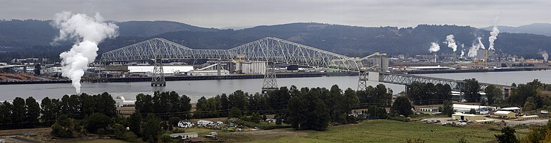
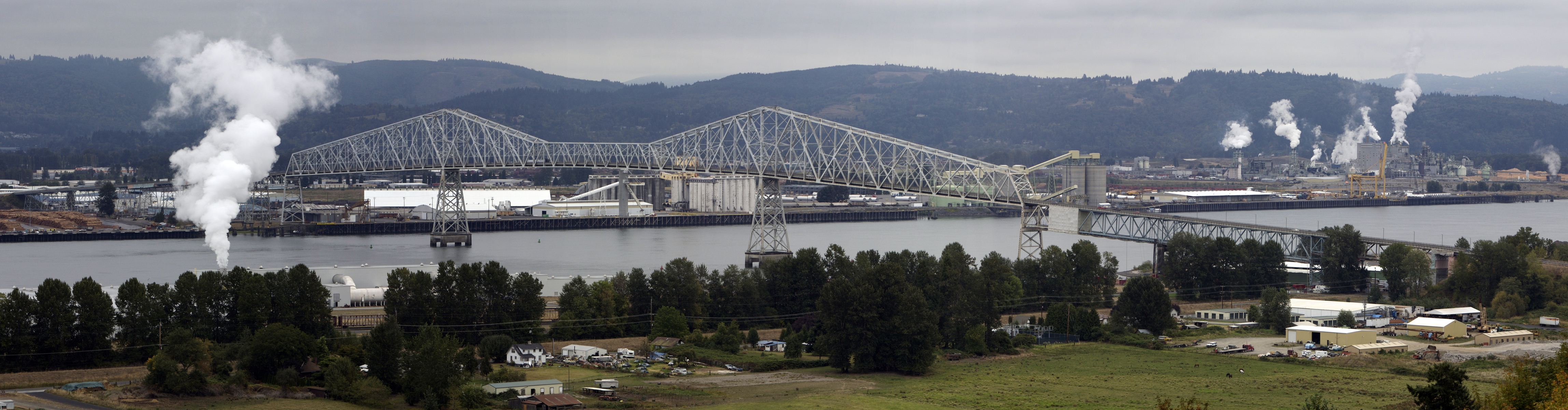
English: The Lewis and Clark Bridge carries Washington State Route 433 across the Columbia River at between the cities of Longview, Washington and Rainier, Oregon. Shot taken from U.S. Route 30 in Oregon looking northeast. This is a stitch of 4 exposures.
Français : Le pont Lewis et Clark permet à la Washington State Route 433 de traverser le fleuve Columbia entre les villes de Longview, Washington et Rainier, Oregon. Photo prise à partir de la US Route 30 dans l'Oregon en direction du nord-est. Cette photo est réalisée par assemblage de 4 clichés.
|
|||||||
| Date | ||||||||
| Source | Own work | |||||||
| Author | Cacophony | |||||||
| Permission (Reusing this file) |
I, the copyright holder of this work, hereby publish it under the following licenses:
You may select the license of your choice. |

| Object location | | View this and other nearby images on: OpenStreetMap - Google Earth |
|---|
|

|
This image has been assessed under the valued image criteria and is considered the most valued image on Commons within the scope: Lewis and Clark Bridge. You can see its nomination here. |
File history
Click on a date/time to view the file as it appeared at that time.
| Date/Time | Thumbnail | Dimensions | User | Comment | |
|---|---|---|---|---|---|
| current | 19:05, 13 September 2007 | 4,593 × 1,200 (2.26 MB) | Cacophony (talk | contribs) | {{Information |Description=The Lewis and Clark Bridge across the Columbia River at Longview, Washington. Seen from the west along U.S. Highway 30. This is a stich of 4 exposures. |Source=self-made |Date=9/12/07 |Author= Cacophony }} |
- You cannot overwrite this file.
File usage on Commons
The following 33 pages uses this file:
- User:Samsara/POTY 2011 overview
- User:Ö/Best/2011
- User talk:Admrboltz/Archive 1
- User talk:Cacophony
- Commons:Featured picture candidates/File:Lewis&ClarkBridgeSP.jpg
- Commons:Featured picture candidates/Log/February 2011
- Commons:Featured pictures/Places/Architecture/Bridges
- Commons:Featured pictures/Places/Panoramas
- Commons:Featured pictures/chronological/2011-A
- Commons:Picture of the Year/2011/Galleries/2011-A
- Commons:Picture of the Year/2011/Galleries/A
- Commons:Picture of the Year/2011/Galleries/A/table
- Commons:Picture of the Year/2011/Galleries/ALL
- Commons:Picture of the Year/2011/Galleries/FEB
- Commons:Picture of the Year/2011/Galleries/Index/2
- Commons:Picture of the Year/2011/Galleries/Index/ALL
- Commons:Picture of the Year/2011/Galleries/Index/Panoramic views
- Commons:Picture of the Year/2011/Galleries/Panoramic views
- Commons:Picture of the Year/2011/Galleries/Panoramic views/Large
- Commons:Picture of the Year/2011/Galleries/Panoramic views/Small
- Commons:Picture of the Year/2011/Galleries/table
- Commons:Picture of the Year/2011/R1/Lewis&ClarkBridgeSP.jpg
- Commons:Picture of the Year/2011/Results/R1/ALL/table
- Commons:Picture of the Year/2011/Results/R1/Panoramic views
- Commons:Picture of the Year/2011/Results/R1/Panoramic views/table
- Commons:Picture of the day/Unused featured pictures
- Commons:Quality images/Subject/Places/Mixed/Panorama
- Commons:Quality images candidates/Archives December 2010
- Commons:Valued image candidates/Lewis&ClarkBridgeSP.jpg
- Commons:Valued images by topic/Places/Buildings/Bridges
- Commons talk:Picture of the Year/2011/Results/R1/ALL/table
- Category:Lewis and Clark Bridge
- Category:Washington State Route 433
File usage on other wikis
The following other wikis use this file:
- Usage on bn.wikipedia.org
- Usage on de.wikipedia.org
- Usage on en.wikipedia.org
- Lewis and Clark Bridge (Columbia River)
- Wikipedia:WikiProject Bridges and Tunnels
- List of crossings of the Columbia River
- List of longest cantilever bridge spans
- Washington State Route 433
- National Register of Historic Places listings in Columbia County, Oregon
- Wikipedia:Featured picture candidates/February-2011
- Wikipedia:Featured picture candidates/Lewis and Clark Bridge Panorama
- Portal:Washington roads/Selected picture/1
- Portal:Washington roads/Selected picture
- User:Fredddie/Watchlist
- User:Another Believer/Travel/United States
- Usage on es.wikipedia.org
- Usage on fr.wikipedia.org
- Usage on nl.wikipedia.org
- Usage on pl.wikipedia.org
- Usage on vi.wikipedia.org
- Usage on www.wikidata.org