Old maps of cities
Contents
- 1 Africa/Afrique
- 2 The Americas/Las Américas
- 3 Asia
- 4 Europe
- 4.1 Belgium/België/Belgique/Belgien
- 4.2 Czech Republic/Česká republika
- 4.3 France
- 4.4 Germany/Deutschland
- 4.5 Greece/Ελλάδα
- 4.6 Ireland/Éire
- 4.7 Italy/Italia
- 4.8 Netherlands/Nederland
- 4.9 Poland/Polska
- 4.10 Russia/Россия
- 4.11 Serbia/Србија
- 4.12 Spain/España
- 4.13 Sweden/Sverige
- 4.14 Ukraine/Україна/Украи́на
- 4.15 United Kingdom
- 5 Middle East
- 6 Oceania
Old maps are included in the ![]() Wikimedia Atlas
Wikimedia Atlas ![]() . The maps below should be included in the atlas.
. The maps below should be included in the atlas.
Africa/Afrique[edit]

Historical map of Tunis
Historical map of Massaua

Historical map of Cape Town

Historical map of Carthage

Historical map of Kinshasa

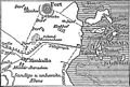
Historical map of Monrovia


The Americas/Las Américas[edit]
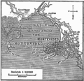
Historical map of Montevideo (1888)

Historical map of Valparaíso (1888)

Historical map of Havana (1888)

Historical map of Buenos Aires (1888)


Brazil/Brasil[edit]

Historical map of Rio de Janeiro (1888)

Historical map of Salvador da Bahia (1888)


Mexico/México[edit]

Historical map of Oaxaca de Juárez (1877)

Peru/Perú[edit]


United States/Estados Unidos[edit]

Historical map of Baltimore (1888)

Historical map of Boston/Massachusetts (1888)

Historical map of Honolulu (1888)
Historical map of New Orleans (1888)

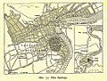
Historical map of Philadelphia/Pennsylvania (1888)
Historical map of San Francisco (1888)

Historical map of Washigton D.C. (1888)

Salem Village, Massachusetts (1692)

Historical Map of Williamsburgh, Brooklyn (1827)

Historical Map of Williamsburgh, Brooklyn (1845)

.jpg)


Asia[edit]

Historical map of Bangkok
Historical map of Jakarta (Batavia)

Historic map of Delhi, 1863
Historical map of Singapur

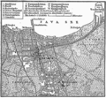
Historical map of Tokyo

Historical map of Constantinople (1493)

Historical map of Ha Noi

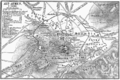
Historical map of Vladivostok when seized by the Czechoslovak Legions on 29 June 1918


China/中国[edit]

Historical map of Shanghai

Historical map of Beijing
Historical map of Shanghai
Historical map of Chengdu

Historical map of Lhasa


India/भारत[edit]

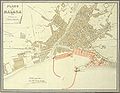
Historical map of Mumbai
Historical map of Kolkata

Historical map of Chennai
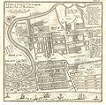
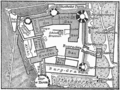
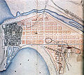
Plan of Fort St George, Chennai 1726

Plan of Fort St George, Chennai 1758

Plan of Fort St George, Chennai 1764

Historical map of Delhi
.jpg)
.jpg)
.jpg)


Europe[edit]

Historical map of Klagenfurt (c. 1735)

Historical map of Lisbon (1888)

Historical map of Pula (Pola) (1888)
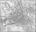
Historical map of Vienna (1888)
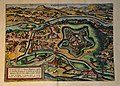
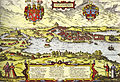
Oradea by Braun & Hogenberg (1617)


Belgium/België/Belgique/Belgien[edit]

Historical map of Antwerpen (1888)


Czech Republic/Česká republika[edit]

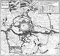
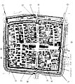
Historical map of Kolín (1640)

France[edit]

Historical map of Brest

Historical map of Brest

Historical map of Brest
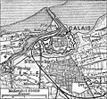
Historical map of Calais
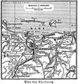
Historical map of Cherbourg

Historical map of Le Havre

Historical map of Marseilles

Historical map of Strasbourg

Historical map of Toulouse

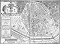
Historical map of castle Versailles


Germany/Deutschland[edit]

Historical map of Apolda (1921)

See also Maps of Berlin

Historical map of Camburg (1921)

Historical map of Darmstadt (1888)

copper-engraving of Dorsten in (1633)
Siege of Dorsten (1641)

Historical map of Dresden (1876)

Historical map of Erfurt (1493)
Historical map of Hamburg (1660)
Historical map of the castle Heidelberg (1888)

Historical map of Heilbronn (1903)

Historical map of Hildesheim (1910)

Maximaler französischer Ausbauplan von Jülich
Historical map of Leipzig (1876)
Historical map of Lübeck

Historical map of Mannheim (1888)
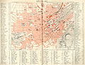
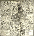
München (Munich) 1858

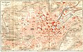
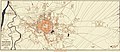
Historical map of Munich (1888)

Historical map of Naumburg (Saale) (1921)

Historical map of Neuruppin (1888)
Historical map of Neustadt an der Donau (1819)

Nuremberg Nürnberg (1858)
Historical map of Schleswig
Historical map of Stuttgart
Historical map of Stuttgart (1893)
Historical map of Weinsberg (1914)
Historical map of Wilhelmshaven (1888)

Historical map of Wiesbaden


Greece/Ελλάδα[edit]
Historical map of Athens

Historical map of Mykene

Historical map of Pergamon


Ireland/Éire[edit]

Kilkenny city, by Sam Byron (c. 1780). small version
*Large version for printing
*A PDF version of the large version with JBIG2-lossless compression
Historical map of Dublin (1888)
.png)

Italy/Italia[edit]

Historical map of Palermo
Historical map of Trieste(1888)

Historical map of Venice

Historical map of the Vesuvius

Historical map of excavations in Pompeij

Historical map of the Po-delta
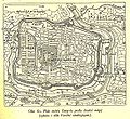
Historical map of Rome with the walls of emperor Aurelianus

Plan of Rome in the Middle Ages

Historical map of La Spezia (1888)


Netherlands/Nederland[edit]
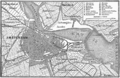
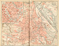
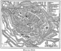
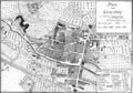
Historical map of Amsterdam (1888)

Historical map of Rotterdam (1888)

Historical map of Venlo (1850)


Poland/Polska[edit]
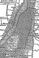
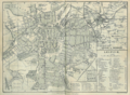
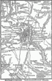
Historical map of Warsaw

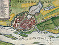
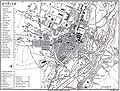
Historical map of Szczecin (former Stettin)
Historical map of Bolesławiec (former Bunzlau)

Lublin in 1783

Lublin in 1875

Map of Łódź in 1853

.jpg)
.jpg)
.jpg)
_-_Micha%C5%82_Denar.jpg)

Russia/Россия[edit]

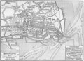
Historical map of Moscow

previous image with some higlighting Moskau

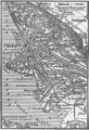
Historical map of St. Petersburg
Historical map of Vladivostok when seized by the Czechoslovak Legions on 29 June 1918


Serbia/Србија[edit]


Spain/España[edit]

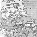
Historical map of Madrid
Barcelona, 1859

Santiago de Compostela, 1595

Historical map of Cádiz

Historical map of the Cadiz bay, circa 1813

Historical map of Salamanca
Málaga, 1887

Plano de Medina del Campo en el siglo XVI
San Sebastián, 1862
Bilbao, 1857
Valencia, siglo XVII

Zaragoza, siglo XVIII


Sweden/Sverige[edit]

Historical map of Karlskrona (1888)

Historical map of Karlskrona

Historical map of Malmö (1580)
Historical map of Stockholm (1888)

Historical map of Uppsala (Before the fire 1702)

Historical map of Uppsala (1770)

Historical map of Uppsala (1920)


_-_from_Busser,_Om_Upsala_Stad_etc.jpg)
_-_from_Busser,_Om_Upsala_Stad_etc.jpg)

Ukraine/Україна/Украи́на[edit]


United Kingdom[edit]

Historical map of Edinburgh (1888)

Historical map of Plymouth (1888)

Historical map of Portsmouth and Southampton (1888)

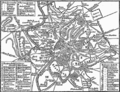
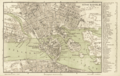
Historical map of Liverpool (1888)

Historical map of Kingston upon Hull (1888)

Historical map of Dover (1888)

Hursley (1607)
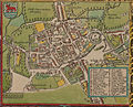
Historical map of Oxford (1605)


Middle East[edit]

Historical map of Ephesos

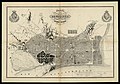
Historical map of Jerusalem (1888)
Historical map of the area surrounding Jerusalem (1888)

Historical map of Troja


Oceania[edit]
Australia[edit]


New Zealand[edit]

Historical map of Auckland

.png)