User:Ainali/gallery 2010
Jump to navigation
Jump to search

Contents
- 1 Sun Oct 03 18:43:57 CEST 2010
- 2 Sun Oct 03 18:42:30 CEST 2010
- 3 Wed Sep 22 22:26:22 CEST 2010
- 4 Wed Sep 22 20:44:04 CEST 2010
- 5 Wed Sep 22 18:51:17 CEST 2010
- 6 Sun Sep 05 19:56:52 CEST 2010
- 7 Wed Aug 25 20:59:38 CEST 2010
- 8 Sun Aug 15 22:17:52 CEST 2010
- 9 Sun Aug 15 21:09:00 CEST 2010
- 10 Sun Aug 15 18:22:11 CEST 2010
- 11 Sun Aug 15 18:19:41 CEST 2010
- 12 Sat Aug 14 19:10:11 CEST 2010
- 13 Sat Aug 14 16:12:51 CEST 2010
- 14 Sat Aug 14 13:24:09 CEST 2010
- 15 Sat Aug 14 12:33:50 CEST 2010
- 16 Wed Aug 11 23:14:10 CEST 2010
- 17 Wed Aug 11 21:36:42 CEST 2010
- 18 Mon Aug 02 19:28:36 CEST 2010
- 19 Sat Jun 19 20:48:50 CEST 2010
- 20 Sat Jun 19 20:06:17 CEST 2010
- 21 Fri Jun 18 23:44:17 CEST 2010
- 22 Fri Jun 18 19:43:00 CEST 2010
- 23 Thu Jun 17 19:11:48 CEST 2010
- 24 Wed Jun 16 22:41:48 CEST 2010
- 25 Wed Jun 16 22:06:46 CEST 2010
- 26 Sun Mar 07 20:00:19 CET 2010
- 27 Tue Jan 05 18:13:49 CET 2010
Sun Oct 03 18:43:57 CEST 2010[edit]
 Svenska: Per Wästberg på bokmässan 2010.

Sun Oct 03 18:42:30 CEST 2010[edit]
errors[edit]
- File:Per_Wästberg_01.JPG aborted
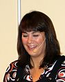 Svenska: Alexandra Zazzi på bokmässan 2010.
 Svenska: Anders Jensen på bokmässan 2010.
 Svenska: Anna Eriksson Baaz på bokmässan 2010.
 Svenska: Anna Tikum på bokmässan 2010.
 Svenska: Annika Broman på bokmässan 2010.
 Svenska: Överblick av bokmässan 2010.
 Svenska: Överblick av bokmässan 2010.
 Svenska: Carl Jan Granqvist på bokmässan 2010.
 Svenska: Elisabeth Sandlundpå bokmässan 2010.
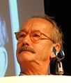 Svenska: Gösta Ekman på bokmässan 2010.
 Svenska: Gösta Ekman på bokmässan 2010.
 Svenska: Igor Ardoris på bokmässan 2010.
 Svenska: Inger Sandberg på bokmässan 2010.
 Svenska: Jan Mårtensson på bokmässan 2010.
 Svenska: Jens Liljestrand på bokmässan 2010.
 Svenska: Jo Nesbø på bokmässan 2010.
 Svenska: Klas Gustafson på bokmässan 2010.
 Svenska: Paolo Roberto på bokmässan 2010.
 Svenska: Per Wästberg på bokmässan 2010.
 Svenska: Stefan Helgesson på bokmässan 2010.
 Svenska: Thomas Lerner på bokmässan 2010.


Wed Sep 22 22:26:22 CEST 2010[edit]
 Svenska: Badstugor i Skanör
Camera location 

View all coordinates using: OpenStreetMap - Google Earth 
 Svenska: Badstugor i Skanör
Camera location 
View all coordinates using: OpenStreetMap - Google Earth  Svenska: Fornborgen i Skanör
Camera location View all coordinates using: OpenStreetMap - Google Earth  Svenska: Fornborgen i Skanör.
Camera location 
View all coordinates using: OpenStreetMap - Google Earth  Svenska: Deltagarna på fotosafari i Skåne.
Camera location 
View all coordinates using: OpenStreetMap - Google Earth  Svenska: Klocka på Rådhustorget i Skanör.
Camera location 
View all coordinates using: OpenStreetMap - Google Earth  Svenska: Livbåtsskjul i Skanörs hamn.
Camera location View all coordinates using: OpenStreetMap - Google Earth  Svenska: Rådhuset i Skanör.
Camera location 
View all coordinates using: OpenStreetMap - Google Earth  Svenska: Skanörs fiskrögeri
Camera location 
View all coordinates using: OpenStreetMap - Google Earth  Svenska: Skanörs hamn
Camera location 
View all coordinates using: OpenStreetMap - Google Earth  Svenska: Skanörs hamn
Camera location 
View all coordinates using: OpenStreetMap - Google Earth  Svenska: Livboj i Skanörs hamn
Camera location 
View all coordinates using: OpenStreetMap - Google Earth 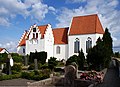 Svenska: Skanörs kyrka
Camera location 
View all coordinates using: OpenStreetMap - Google Earth  Svenska: Skanörs kyrka
Camera location View all coordinates using: OpenStreetMap - Google Earth 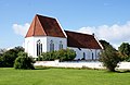 Svenska: Skanörs kyrka
Camera location 
View all coordinates using: OpenStreetMap - Google Earth  Svenska: Skanörs kyrka
Camera location View all coordinates using: OpenStreetMap - Google Earth  Svenska: Skanörsmöllan
Camera location View all coordinates using: OpenStreetMap - Google Earth  Svenska: Skanörsmöllan
Camera location View all coordinates using: OpenStreetMap - Google Earth


Wed Sep 22 20:44:04 CEST 2010[edit]
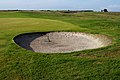 Svenska: Bunker på Falsterbo GK.
Camera location View all coordinates using: OpenStreetMap - Google Earth  Svenska: Ett elskåp vid parkeringen på Falsterbo GK.
Camera location View all coordinates using: OpenStreetMap - Google Earth  Svenska: Fairway på Falsterbo GK.
Camera location View all coordinates using: OpenStreetMap - Google Earth  Svenska: Fairway på Falsterbo GK.
Camera location View all coordinates using: OpenStreetMap - Google Earth  Svenska: Green på Falsterbo GK
Camera location View all coordinates using: OpenStreetMap - Google Earth  Svenska: Falsterbo GK klubbhus.
Camera location View all coordinates using: OpenStreetMap - Google Earth 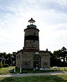 Svenska: Falsterbo fyr.
Camera location View all coordinates using: OpenStreetMap - Google Earth  Svenska: Falsterbo kyrka.
Camera location View all coordinates using: OpenStreetMap - Google Earth  Svenska: Falsterbo kyrka.
Camera location View all coordinates using: OpenStreetMap - Google Earth  Svenska: Falsterbo kyrka.
Camera location View all coordinates using: OpenStreetMap - Google Earth  Svenska: Falsterbohus slott.
Camera location View all coordinates using: OpenStreetMap - Google Earth  Svenska: Fru Alstads kyrka.
Camera location View all coordinates using: OpenStreetMap - Google Earth  Svenska: Fru Alstads kyrka.
Camera location View all coordinates using: OpenStreetMap - Google Earth  Svenska: Fru Alstads kyrka från orgelplatsen.
Camera location View all coordinates using: OpenStreetMap - Google Earth  Svenska: Fru Alstads kyrka
Camera location View all coordinates using: OpenStreetMap - Google Earth  Svenska: Fru Alstads kyrka
Camera location 
View all coordinates using: OpenStreetMap - Google Earth  Svenska: Väggmålning i Fru Alstads kyrka.
Camera location View all coordinates using: OpenStreetMap - Google Earth 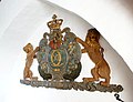 Svenska: Karl X1 vapen i Fru Alstads kyrka.
Camera location View all coordinates using: OpenStreetMap - Google Earth  Svenska: Krucifx i Fru Alstads kyrka.
Camera location View all coordinates using: OpenStreetMap - Google Earth  Svenska: Målning från 1743 i Fru Alstads kyrka.
Camera location View all coordinates using: OpenStreetMap - Google Earth  Svenska: Hammarlövs kyrka
Camera location View all coordinates using: OpenStreetMap - Google Earth 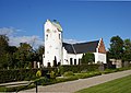 Svenska: Hammarlövs kyrka
Camera location View all coordinates using: OpenStreetMap - Google Earth 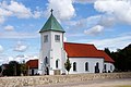 Svenska: Hemmesdynge kyrka
Camera location View all coordinates using: OpenStreetMap - Google Earth  Svenska: Hemmesdynge kyrka
Camera location View all coordinates using: OpenStreetMap - Google Earth  Svenska: En kalkugn i Östra torp
Camera location View all coordinates using: OpenStreetMap - Google Earth  Svenska: Insidan på en kalkugn i Östra torp.
Camera location View all coordinates using: OpenStreetMap - Google Earth  Svenska: Insidan på en kalkugn i Östra torp.
Camera location View all coordinates using: OpenStreetMap - Google Earth  Svenska: Kolabacken bredvid Falsterbo GK.
Camera location 
View all coordinates using: OpenStreetMap - Google Earth


Wed Sep 22 18:51:17 CEST 2010[edit]
 Svenska: Landsvägen, gata i centrala Anderslöv.
Camera location View all coordinates using: OpenStreetMap - Google Earth 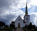 Svenska: Anderslövs kyrka
Camera location View all coordinates using: OpenStreetMap - Google Earth  Svenska: Anderslövs kyrka
Camera location View all coordinates using: OpenStreetMap - Google Earth  Svenska: Anderslövs kyrka.
Camera location View all coordinates using: OpenStreetMap - Google Earth  Svenska: Staty på torget i Anderslöv.
Camera location View all coordinates using: OpenStreetMap - Google Earth  Svenska: Torget i Anderslöv.
Camera location View all coordinates using: OpenStreetMap - Google Earth  Svenska: Död duva utanför Fru Alstads kyrka.
Camera location View all coordinates using: OpenStreetMap - Google Earth  Svenska: Hästgården i Fredshög.
Camera location 
View all coordinates using: OpenStreetMap - Google Earth  Svenska: Hästgården i Fredshög.
Camera location View all coordinates using: OpenStreetMap - Google Earth  Svenska: Kyrkplatsen i Kämpinge
Camera location View all coordinates using: OpenStreetMap - Google Earth  Svenska: Lilla Beddinge gamla kyrkogård
Camera location View all coordinates using: OpenStreetMap - Google Earth  Svenska: Lilla Beddinge gamla kyrkogård
Camera location View all coordinates using: OpenStreetMap - Google Earth  Svenska: Lilla Beddinge gamla kyrkogård.
Camera location View all coordinates using: OpenStreetMap - Google Earth  Svenska: Fält med sockerbetor i Skåne. Villie högar i bakgrunden.
 Svenska: Bronsåldershögarna Villie högar.
 Svenska: Okänd blomma med okänd insekt
Camera location View all coordinates using: OpenStreetMap - Google Earth  Svenska: Okänd spindel i nät.
Camera location View all coordinates using: OpenStreetMap - Google Earth


Sun Sep 05 19:56:52 CEST 2010[edit]
 Svenska: Eskilstorpsdösen
Camera location View all coordinates using: OpenStreetMap - Google Earth 
This file was uploaded with Commonist.  Svenska: Eskilstorpsdösen
Camera location View all coordinates using: OpenStreetMap - Google Earth This file was uploaded with Commonist.  Svenska: Eskilstorpsdösen
Camera location View all coordinates using: OpenStreetMap - Google Earth This file was uploaded with Commonist. 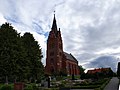 Svenska: Fuglie kyrka
Camera location View all coordinates using: OpenStreetMap - Google Earth This file was uploaded with Commonist. 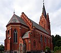 Svenska: Fuglie kyrka
Camera location View all coordinates using: OpenStreetMap - Google Earth This file was uploaded with Commonist.  Svenska: Fuglie kyrka
Camera location View all coordinates using: OpenStreetMap - Google Earth This file was uploaded with Commonist.  Svenska: Fugliestenen 1 (DR 259)
Camera location View all coordinates using: OpenStreetMap - Google Earth This file was uploaded with Commonist.  Svenska: Fugliestenen 2 (DR 260)
Camera location View all coordinates using: OpenStreetMap - Google Earth This file was uploaded with Commonist.  Svenska: Hanehög
Camera location View all coordinates using: OpenStreetMap - Google Earth This file was uploaded with Commonist.  Svenska: Håslövs kyrka
Camera location 
View all coordinates using: OpenStreetMap - Google Earth This file was uploaded with Commonist.  Svenska: Håslövs kyrka
Camera location View all coordinates using: OpenStreetMap - Google Earth This file was uploaded with Commonist.  Svenska: Håslövs kyrka
Camera location View all coordinates using: OpenStreetMap - Google Earth This file was uploaded with Commonist.  Svenska: Skulptur i Hököpinge framför sockerfabriken.
Camera location View all coordinates using: OpenStreetMap - Google Earth This file was uploaded with Commonist.  Svenska: Hököpinge kyrka
Camera location View all coordinates using: OpenStreetMap - Google Earth This file was uploaded with Commonist.  Svenska: Hököpinge sockerfabrik
Camera location View all coordinates using: OpenStreetMap - Google Earth This file was uploaded with Commonist.  Svenska: Klosterdammen
Camera location View all coordinates using: OpenStreetMap - Google Earth This file was uploaded with Commonist.  Svenska: Månstorps gavlar.
Camera location View all coordinates using: OpenStreetMap - Google Earth This file was uploaded with Commonist.  Svenska: Månstorps gavlar.
Camera location View all coordinates using: OpenStreetMap - Google Earth This file was uploaded with Commonist. 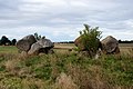 Svenska: Dubbelgånggrift i Snarringe.
Camera location View all coordinates using: OpenStreetMap - Google Earth This file was uploaded with Commonist.  Svenska: Dubbelgånggrift i Snarringe
Camera location View all coordinates using: OpenStreetMap - Google Earth This file was uploaded with Commonist.  Svenska: Dubbelgånggrift i Snarringe
Camera location View all coordinates using: OpenStreetMap - Google Earth This file was uploaded with Commonist.  Svenska: Utsikt från Bolmers högar
Camera location View all coordinates using: OpenStreetMap - Google Earth This file was uploaded with Commonist.  Svenska: Vellinge Gästgiveri
Camera location View all coordinates using: OpenStreetMap - Google Earth This file was uploaded with Commonist. 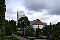 Svenska: Vellinge kyrka
Camera location View all coordinates using: OpenStreetMap - Google Earth This file was uploaded with Commonist.  Svenska: Vellinge kyrka
Camera location View all coordinates using: OpenStreetMap - Google Earth This file was uploaded with Commonist. 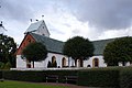 Svenska: Vellinge kyrka
Camera location View all coordinates using: OpenStreetMap - Google Earth This file was uploaded with Commonist.  Svenska: Vellinge stadspark
Camera location View all coordinates using: OpenStreetMap - Google Earth This file was uploaded with Commonist. 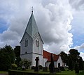 Svenska: Västra Ingelstads kyrka
Camera location View all coordinates using: OpenStreetMap - Google Earth This file was uploaded with Commonist.  Svenska: Västra Ingelstads kyrka
Camera location View all coordinates using: OpenStreetMap - Google Earth This file was uploaded with Commonist.  Svenska: Altarsxåpet i Västra Ingelstads kyrka
Camera location View all coordinates using: OpenStreetMap - Google Earth This file was uploaded with Commonist.  Svenska: Interiör i Västra Ingelstads kyrka
Camera location View all coordinates using: OpenStreetMap - Google Earth This file was uploaded with Commonist.  Svenska: Interiör i Västra Ingelstads kyrka
Camera location View all coordinates using: OpenStreetMap - Google Earth This file was uploaded with Commonist.  Svenska: Den lilla orgeln i Västra Ingelstads kyrka
Camera location View all coordinates using: OpenStreetMap - Google Earth This file was uploaded with Commonist.  Svenska: Orgeln i Västra Ingelstads kyrka
Camera location View all coordinates using: OpenStreetMap - Google Earth This file was uploaded with Commonist.  Svenska: Predikstolne i Västra Ingelstads kyrka
Camera location View all coordinates using: OpenStreetMap - Google Earth This file was uploaded with Commonist.  Svenska: Stentavla i Västra Ingelstads kyrka
Camera location View all coordinates using: OpenStreetMap - Google Earth This file was uploaded with Commonist.  Svenska: Söderslätt
This file was uploaded with Commonist.  Svenska: Östra Grevie kyrka
Camera location View all coordinates using: OpenStreetMap - Google Earth This file was uploaded with Commonist.  Svenska: Östra Grevie kyrka
Camera location View all coordinates using: OpenStreetMap - Google Earth This file was uploaded with Commonist.  Svenska: Östra Grevie kyrka
Camera location View all coordinates using: OpenStreetMap - Google Earth This file was uploaded with Commonist.  Svenska: Östra Grevie kyrka
Camera location View all coordinates using: OpenStreetMap - Google Earth This file was uploaded with Commonist.


_2010.jpg)
_2010.jpg)


Wed Aug 25 20:59:38 CEST 2010[edit]
 Svenska: Ali Esbati, Vänsterpartiet.
 Svenska: Ali Esbati, Vänsterpartiet.
 Svenska: Alice Åström, Vänsterpartiet.
 Svenska: Alice Åström, Vänsterpartiet.
 Svenska: , Vänsterpartiet.
 Svenska: , Vänsterpartiet.
 Svenska: Anki Ahlsten, Vänsterpartiet.
 Svenska: Anki Ahlsten, Vänsterpartiet.
 Svenska: Anna Hövenmark, Vänsterpartiet.
 Svenska: Anna Hövenmark, Vänsterpartiet.
 Svenska: Annamaria Bauer, Vänsterpartiet.
 Svenska: Annamaria Bauer, Vänsterpartiet.
 Svenska: Anneli Philipsson, Vänsterpartiet.
 Svenska: , Vänsterpartiet.
 Svenska: , Vänsterpartiet.
 Svenska: Anneli Philipsson, Vänsterpartiet.
 Svenska: Christina Höj Larsen, Vänsterpartiet.
 Svenska: Christina Höj Larsen, Vänsterpartiet.
 Svenska: Claes Wallenius, Vänsterpartiet.
 Svenska: Claes Wallenius, Vänsterpartiet.
 Svenska: Daniel Riazat, Vänsterpartiet.
 Svenska: Daniel Riazat, Vänsterpartiet.
 Svenska: Dror Feiler, Vänsterpartiet.
 Svenska: Dror Feiler, Vänsterpartiet.
 Svenska: Egon Frid, Vänsterpartiet.
 Svenska: , Vänsterpartiet.
 Svenska: , Vänsterpartiet.
 Svenska: Egon Frid, Vänsterpartiet.
 Svenska: Eva Olofsson, Vänsterpartiet.
 Svenska: Eva Olofsson, Vänsterpartiet.
 Svenska: Hans Linde, Vänsterpartiet.
 Svenska: Hans Linde, Vänsterpartiet.
 Svenska: Henrik Holmqvist Dinamarca, Vänsterpartiet.
 Svenska: Henrik Holmqvist Dinamarca, Vänsterpartiet.
 Svenska: Ida Gabrielsson, Vänsterpartiet.
 Svenska: Ida Gabrielsson, Vänsterpartiet.
 Svenska: Ida Lagnermark, Vänsterpartiet.
 Svenska: Ida Lagnermark, Vänsterpartiet.
 Svenska: Jacob Johnson, Vänsterpartiet.
 Svenska: Jacob Johnson, Vänsterpartiet.
 Svenska: Jenny Wrangborg, Vänsterpartiet.
 Svenska: Jenny Wrangborg, Vänsterpartiet.
 Svenska: Jens Holm, Vänsterpartiet.
 Svenska: Jens Holm, Vänsterpartiet.
 Svenska: Jesper Odelberg, Vänsterpartiet.
 Svenska: Jesper Odelberg, Vänsterpartiet.
 Svenska: Jonas Sjöstedt, Vänsterpartiet.
 Svenska: Jonas Sjöstedt, Vänsterpartiet.
 Svenska: Josefin Brink, Vänsterpartiet.
 Svenska: Josefin Brink, Vänsterpartiet.
 Svenska: Jörgen Persson, Vänsterpartiet.
 Svenska: Jörgen Persson, Vänsterpartiet.
 Svenska: Kaj Raving, Vänsterpartiet.
 Svenska: Kaj Raving, Vänsterpartiet.
 Svenska: Kalle Larsson, Vänsterpartiet.
 Svenska: Kalle Larsson, Vänsterpartiet.
 Svenska: Kent Persson, Vänsterpartiet.
 Svenska: Kent Persson, Vänsterpartiet.
 Svenska: Kristina Hallberg, Vänsterpartiet.
 Svenska: Kristina Hallberg, Vänsterpartiet.
 Svenska: Lars Ohly, Vänsterpartiet.
 Svenska: Lars Ohly, Vänsterpartiet.
 Svenska: Leif Lindström, Vänsterpartiet.
 Svenska: Leif Lindström, Vänsterpartiet.
 Svenska: Lena Olsson, Vänsterpartiet.
 Svenska: Lena Olsson, Vänsterpartiet.
 Svenska: Maria Chergui, Vänsterpartiet.
 Svenska: Maria Chergui, Vänsterpartiet.
 Svenska: Marianne Berg, Vänsterpartiet.
 Svenska: Marianne Berg, Vänsterpartiet.
 Svenska: Marianne Ericsson, Vänsterpartiet.
 Svenska: Marianne Ericsson, Vänsterpartiet.
 Svenska: Marlene Svensson, Vänsterpartiet.
 Svenska: Marlene Svensson, Vänsterpartiet.
 Svenska: Martina Nilsson, Vänsterpartiet.
 Svenska: Martina Nilsson, Vänsterpartiet.
 Svenska: Mats Einarsson, Vänsterpartiet.
 Svenska: Mats Einarsson, Vänsterpartiet.
 Svenska: Mats Pilhem, Vänsterpartiet.
 Svenska: Mats Pilhem, Vänsterpartiet.
 Svenska: Mia Sydow Mölleby, Vänsterpartiet.
 Svenska: Mia Sydow Mölleby, Vänsterpartiet.
 Svenska: MonaLisa Norrman, Vänsterpartiet.
 Svenska: MonaLisa Norrman, Vänsterpartiet.
 Svenska: Mussie Ephrem, Vänsterpartiet.
 Svenska: Mussie Ephrem, Vänsterpartiet.
 Svenska: Peter Ahlbom, Vänsterpartiet.
 Svenska: Peter Ahlbom, Vänsterpartiet.
 Svenska: Rossana Dinamarca, Vänsterpartiet.
 Svenska: Rossana Dinamarca, Vänsterpartiet.
 Svenska: Ruzica Stanojvic, Vänsterpartiet.
 Svenska: Ruzica Stanojvic, Vänsterpartiet.
 Svenska: Siv Holma, Vänsterpartiet.
 Svenska: Siv Holma, Vänsterpartiet.
 Svenska: Tamara Spiric, Vänsterpartiet.
 Svenska: Tamara Spiric, Vänsterpartiet.
 Svenska: Torbjörn Björklund, Vänsterpartiet.
 Svenska: Torbjörn Björklund, Vänsterpartiet.
 Svenska: Ulla Andersson, Vänsterpartiet.
 Svenska: Ulla Andersson, Vänsterpartiet.
 Svenska: Vilmer Andersen, Vänsterpartiet.
 Svenska: Vilmer Andersen, Vänsterpartiet.
 Svenska: Wiwi Anne Johansson, Vänsterpartiet.
 Svenska: Wiwi Anne Johansson, Vänsterpartiet.


Sun Aug 15 22:17:52 CEST 2010[edit]
 Svenska: Ane Brun på Stockholms Kulturfestival 2010
Camera location View all coordinates using: OpenStreetMap - Google Earth This file was uploaded with Commonist.  Svenska: Ane Brun på Stockholms Kulturfestival 2010
Camera location View all coordinates using: OpenStreetMap - Google Earth This file was uploaded with Commonist.  Svenska: Catherine Hansson på Stockholms Kulturfestival 2010
Camera location View all coordinates using: OpenStreetMap - Google Earth This file was uploaded with Commonist.  Svenska: Catherine Hansson på Stockholms Kulturfestival 2010
Camera location View all coordinates using: OpenStreetMap - Google Earth This file was uploaded with Commonist.  Svenska: Catherine Hansson på Stockholms Kulturfestival 2010
Camera location View all coordinates using: OpenStreetMap - Google Earth This file was uploaded with Commonist.  Svenska: Cirkus Cirkör på Stockholms Kulturfestival 2010
Camera location View all coordinates using: OpenStreetMap - Google Earth This file was uploaded with Commonist.  Svenska: Cirkus Cirkör på Stockholms Kulturfestival 2010
Camera location View all coordinates using: OpenStreetMap - Google Earth This file was uploaded with Commonist.  Svenska: Cirkus Cirkör på Stockholms Kulturfestival 2010
Camera location View all coordinates using: OpenStreetMap - Google Earth This file was uploaded with Commonist.


Sun Aug 15 21:09:00 CEST 2010[edit]

Camera location View all coordinates using: OpenStreetMap - Google Earth This file was uploaded with Commonist. 
Camera location View all coordinates using: OpenStreetMap - Google Earth This file was uploaded with Commonist. 
Camera location View all coordinates using: OpenStreetMap - Google Earth This file was uploaded with Commonist. 
Camera location View all coordinates using: OpenStreetMap - Google Earth This file was uploaded with Commonist.


Sun Aug 15 18:22:11 CEST 2010[edit]
 Svenska: Carl Johan De Geer på Stokholms Kulturfestival 2010
Camera location View all coordinates using: OpenStreetMap - Google Earth This file was uploaded with Commonist.

Sun Aug 15 18:19:41 CEST 2010[edit]
 Svenska: Barbro Lindgren på Stokholms Kulturfestival 2010
Camera location View all coordinates using: OpenStreetMap - Google Earth This file was uploaded with Commonist.  Svenska: Världens längsta bokbord på Stokholms Kulturfestival 2010
Camera location View all coordinates using: OpenStreetMap - Google Earth This file was uploaded with Commonist.  Svenska: Carl Johan De Geer på Stokholms Kulturfestival 2010
Camera location View all coordinates using: OpenStreetMap - Google Earth This file was uploaded with Commonist.  Svenska: Carl Johan De Geer på Stokholms Kulturfestival 2010
Camera location View all coordinates using: OpenStreetMap - Google Earth This file was uploaded with Commonist. 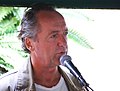 Svenska: Ernst Brunner på Stokholms Kulturfestival 2010
Camera location View all coordinates using: OpenStreetMap - Google Earth This file was uploaded with Commonist.  Svenska: Helena von Zweigbergk på Stokholms Kulturfestival 2010
Camera location View all coordinates using: OpenStreetMap - Google Earth This file was uploaded with Commonist.


Sat Aug 14 19:10:11 CEST 2010[edit]

Camera location View all coordinates using: OpenStreetMap - Google Earth 
Camera location View all coordinates using: OpenStreetMap - Google Earth 
Camera location View all coordinates using: OpenStreetMap - Google Earth


Sat Aug 14 16:12:51 CEST 2010[edit]
 Svenska: Ida Jessen på Stockholms Kulturfestival
 Svenska: Pia Juul på Stockholms Kulturfestival


Sat Aug 14 13:24:09 CEST 2010[edit]

Camera location View all coordinates using: OpenStreetMap - Google Earth 
Camera location View all coordinates using: OpenStreetMap - Google Earth 
Camera location View all coordinates using: OpenStreetMap - Google Earth 
Camera location View all coordinates using: OpenStreetMap - Google Earth 
Camera location View all coordinates using: OpenStreetMap - Google Earth 
Camera location View all coordinates using: OpenStreetMap - Google Earth 
Camera location View all coordinates using: OpenStreetMap - Google Earth 
Camera location View all coordinates using: OpenStreetMap - Google Earth 
Camera location View all coordinates using: OpenStreetMap - Google Earth


Sat Aug 14 12:33:50 CEST 2010[edit]


Wed Aug 11 23:14:10 CEST 2010[edit]

Camera location View all coordinates using: OpenStreetMap - Google Earth 
Camera location View all coordinates using: OpenStreetMap - Google Earth


Wed Aug 11 21:36:42 CEST 2010[edit]

Camera location View all coordinates using: OpenStreetMap - Google Earth 
Camera location View all coordinates using: OpenStreetMap - Google Earth 
Camera location View all coordinates using: OpenStreetMap - Google Earth 
Camera location View all coordinates using: OpenStreetMap - Google Earth 
Camera location View all coordinates using: OpenStreetMap - Google Earth


Mon Aug 02 19:28:36 CEST 2010[edit]

Link made to use this picture: http://toolserver.org/~kolossos/wp-world/imageworld-art-new.php?so=en&fa=2

Link made to use this picture: http://toolserver.org/~kolossos/wp-world/imageworld-art-new.php?la=da&fa=2

Link made to use this picture: http://toolserver.org/~kolossos/wp-world/imageworld-art-new.php?la=fi&fa=2

Link made to use this picture: http://toolserver.org/~kolossos/wp-world/imageworld-art-new.php?la=no&fa=2

Link made to use this picture: http://toolserver.org/~kolossos/wp-world/imageworld-art-new.php?la=sv&fa=2


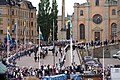
Sat Jun 19 20:48:50 CEST 2010[edit]
 Svenska: Bröllopet mellan kronprinsessan Victoria och Daniel Westling; Innan kortegen på Strandvägen.
 Svenska: Bröllopet mellan kronprinsessan Victoria och Daniel Westling; Innan kortegen mot Djurgården


Sat Jun 19 20:06:17 CEST 2010[edit]

 Svenska: Bröllopet mellan kronprinsessan Victoria och Daniel Westling; Överflygning med JAS 39 Gripen


Fri Jun 18 23:44:17 CEST 2010[edit]
errors[edit]
- File:ForsbackaBruk02.JPG aborted


