Commons:Graphic Lab/Map workshop
| Illustration workshop |
Map workshop |
Photography workshop |
Video and sound workshop |
 Map workshop
This workshop is part of the Graphics Lab, a project aimed at picture retouching to improve the graphical content of the Wikimedia projects. More information about the lab can be found on its main page and requests pages (Illustrations ; Photographs ; Maps ; Video and Sound). To ask questions or make a suggestions, see the talk page of the graphic lab page.
This specific page is the requests page for the Map Workshop. Anyone can make a request for a map to be created or improved. The standard format for making a request is shown below, along with general advice, and should be followed.
Make a request
Use the following template when making a new request, replacing the examples with your image(s) and request(s):
<gallery>
 IMAGENAME.EXT|Description of image
 IMAGE#TWO.EXT|2nd image (If there is one)
 ETCETCETC.EXT|Don't request too many at once, though
</gallery>

;Request:
: Details of your request go here… --~~~~
;Graphist opinion(s):
See also[edit]
- Category:Images for cleanup
- meta:Philip Greenspun illustration project/Requests
- Wikipedia:Graphic Lab/Map workshop (higher traffic, requests may be fulfilled quicker at the Wikipedia lab)
|
||||||||
|
|
SpBot archives all sections tagged with {{Section resolved|1=~~~~}} after 7 days and sections whose oldest comment is older than 185 days. For the archive overview, see /Archive. The latest archive is located at /Archive/2016. |
Contents
- 1 Map workshop
- 2 Make a request
- 3 See also
- 4 Ahmedabad Metro map
- 5 Age of Consent
- 6 Channels of the Hawaiian Islands
- 7 Request for ethnicity maps of Detroit
- 8 MH370 PNG maps - Chinese requested
- 9 Map of Rome
- 10 Maps of the Houston Independent School District
- 11 Updating Holy Roman Empire maps
- 12 Scale is messed up
- 13 Malay and Chinese versions of MH17 maps
- 14 Improve Iceland outline
- 15 Location maps of Sri Lanka
- 16 Jasenovac concentracion camp map to SVG
- 17 Convert PNG map to SVG
- 18 Al Jawf location map
- 19 Pakistan Sindh
Ahmedabad Metro map[edit]
-
Ahmedabad Metro Phase 1 map (old)
- Article(s)
- Request
- Ahmedabad Metro (MEGA) Phase 1 corridors are tweaked with new alignment and more stations. The current image needs update. The new map can be found here on official website: [1] It is PNG image. Please create new SVG image with Commons colour scheme. Regards --Nizil Shah (talk) 20:03, 12 April 2015 (UTC)
- Graphist opinion(s)
Age of Consent[edit]
-
Global age of consent
-

North America
- Article(s)
- Many
- Request
- Add details for Mexico to File:Age of Consent - Global.svg, as was done for the United States and Australia. --Delphi234 (talk) 03:17, 27 May 2015 (UTC)
- Graphist opinion(s)
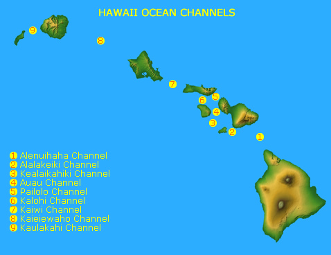
Channels of the Hawaiian Islands[edit]
-
IMAGE1.EXT
Description of first image
-
IMAGE2.EXT
Description of second image (if needed)
-
IMAGE3.EXT
Description of third image (if needed; don't request too many at once, though)
- Article(s)
- w:Channels of the Hawaiian Islands
- Request
- Please create a map indicating all the channels of the Hawaiian Islands using maps of the island chain found on Category:Maps of Hawaii. The result should look something like this. -- KAVEBEAR (talk) 16:26, 3 June 2015 (UTC)
- Graphist opinion(s)
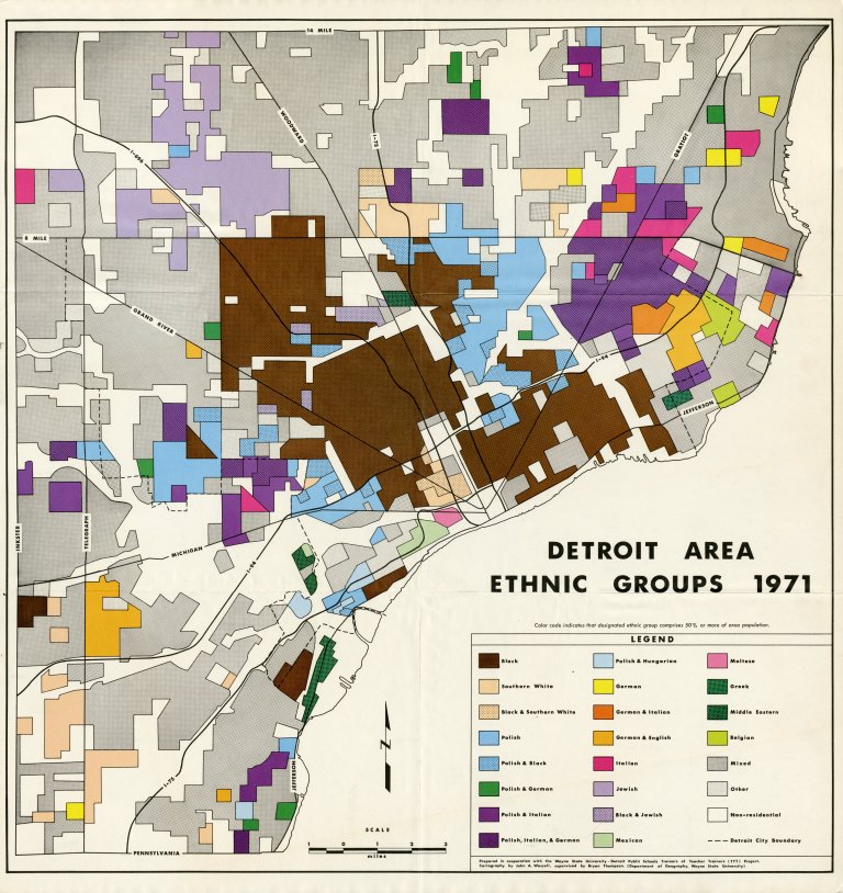
Request for ethnicity maps of Detroit[edit]
-
???
????
- Article(s)
- en:Ethnic groups in Metro Detroit
- Request
- Please take this map from the Detroit Public Library (Archive) (covering 1900-1950) and make a new color version of it. See info page (Archive)
- Please also make a new version of this 1971 ethnicity map (Archive) which, according to the Detroit Historical Society, originated from Wayne State University (Archive)
Thanks, --WhisperToMe (talk) 02:35, 3 July 2015 (UTC)
- Graphist opinion(s)
MH370 PNG maps - Chinese requested[edit]
-
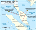
Flight path
-
ATC and air routes
-
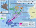
- Article(s)
- MH370
- Request
- Simplified Chinese translations of the following maps requested:
Key for File:MH370 flight path with English labels.png:
- Malaysia Airlines Flight 370 Known Flight Path - 马航370航班的已知路径
- Source: Joint Investigation Team - 来源:联合调查组
- Departs KLIA 12:41 MYT (16:41 UTC) - 于12:41大马标准时间(协调世界时16:41)在吉隆坡国际机场出发
- Last ACARS message 1:06 MYT (17:06 UTC) - 最后飞机通信寻址与报告系统信息 (ACARS)于1:06大马标准时间(协调世界时 17:06)发出
- Last secondary radar contact 01:22 MYT (17:22 UTC) - 最后与二次雷达接触的大马标准时间为 01:22 (协调世界时 17:22)
- 200nm (370km/230mi) - 200海里 (370公里/230英里)
- Last primary radar contact 02:22 MYT (18:22 UTC) - 最后与一次雷达接触的大马标准时间为 02:22 (协调世界时 18:22)
- Andaman Sea - 安达曼海
- Nicobar Islands (India) - 尼科巴群岛 (印度)
- Indian Ocean - 印度洋
- Indonesia - 印尼
- Banda Aceh - 亚齐
- Medan - 棉兰
- Malaysia - 马来西亚
- Ipoh - 怡保
- Kuala Terengganu - 瓜拉登嘉楼
- Penang - 槟城
- Kuala Lumpur - 吉隆坡
- Singapore - 新加坡
- Thailand - 泰国
- Hat Yai - 合艾
- Vietnam - 越南
- Can Tho - 芹苴
- Ho Chi Minh City - 胡志明市
- Cambodia - 柬埔寨
- Gulf of Thailand - 泰国湾
- 10oN - 北纬10度
- 5oN - 北纬5度
- 0o - 赤道0度
Key for File:MH370 ATC and air routes map.png
- Malaysia Airlines Flight 370 Air Traffic Control and Air Routes - 马航370航班空管和空中航线
- FIR Ho Chi Minh - 胡志明市飞航情报区
- FIR Singapore - 新加坡飞航情报区
- FIR Bangkok - 曼谷飞航情报区
- FIR Kuala Lumpur - 吉隆坡飞航情报区
- Gulf of Thailand - 泰国湾飞航情报区
- South China Sea - 南中国海
- Malaysia - 马来西亚
- Kuala Terengganu - 瓜拉登嘉楼
- Kota Bharu - 哥打巴鲁
- Thailand - 泰国
- Narathiwat - 那拉提瓦
- Vietnam - 越南
- 105oE - 东经105度
- 7oN - 北纬7度
- ATC for routes M765 & R208 through FIR Singapore provided by Kuala Lumpur ACC - 通过新加坡飞航情报区M765和R208的空管航线是由吉隆坡区域管制中心所提供
- Disappears from secondary radar (1:21 MYT) - 从二次雷达中消失 (大马标准时间 1:21)
- Flight path - secondary radar - 二次雷达所探测到的飞行路径
- Flight path - military radar - 军用雷达所探测到的飞行路径
- Planned Flight Path - 原定飞行路径
- Flight Information Region (FIR) - 飞航情报区
- FIR Boundaries (includes international border) - 飞航情报区边界(包括国际边界)
- Air route (selected named) - 特定空中航线
- Navigational waypoint (selected) - 特定导航点
- International border (also forms FIR boundary) - 国际边界(也形成飞航情报区边界)
- 1. Source: MH370 - Definition of Underwater Search Areas Australian Transport Safety Bureau, June 2014, pg. 3 - 来源:《MH370 - 水下搜索区域的界定》,第3页, 由澳洲交通安全局于2014年6月发布。
- 2. Based on the flight path taken by MAS Flight 370 in several flights shortly before 8 March 2014. - 根据2014年3月8日前夕的MH370数次航班的飞行路径。
File:MH370 SIO search.png (Translation by User:Cerevisae):
   The Search for Malaysia Airlines Flight 370
   In the Southern Indian Ocean (through July 2015) - 搜寻马来西亚航空公司航班370
   在南印度洋(至2015年7日)
   104oE - 东经104度
   103o50' E - 东经103度50分
   45oS - 南纬45度 (and so on)
   Elevation (metres) - 海拔(米)
   7th BTO arc - Location (distance from satellite) of Flight 370 at the time of its last transmission (8:19 MYT / 00:19 UTC, 8 March 2014) - 第七突发时序偏移弧 - 370航班的位置(与卫星的距离)(break)在当时的最后一次发送的时间 (break)(大马标准时间 8:19/协调世界时 00:19,2014年3月8日)
   Above sea level - 海拔(米)
   Cocos Is. (Australia) - 科科斯群島 (澳洲)
   Detected by sonobuoy - 由声纳浮标所检测
   Location (area of uncertainty) of an event detected by hydrophone stations about at 1:30 UTC, 8 March 2014 - 于2014年3月8日协调世界时 1:30(break)通过水听器站点所检测到的地点(不确定区)的有关事件
   Search areas 3-11 April 2014 - 4月3日至11日的搜索区域
   Search areas 12-28 April 2014 - 4月12日至28日的搜索领域
   Broken Ridge - 布罗肯海岭
   Search areas 28 March - 3 April 2014 - 3月28日至4月3日的搜索领域
   TPL search & seafloor sonar survey (inset) - 拖行声波定位器搜索和海底声呐调查(插图)
   Search areas 18 - 27 March 2014 - 3月18日至27日的搜索区域
   Australia - 澳洲
   Amsterdam Is. (France) - 阿姆斯特丹岛 (法国)
   Saint Paul Is. (France) - 圣保罗岛(法国)
   Perth Canyon (IMOS) - 珀斯峡谷 (综合海洋观测系统)
   Perth - 珀斯
   RAAF Base Perce - 澳大利亚皇家空军的皮尔斯基地
   Fremantle Harbour - 弗里曼特尔海港
   Cape Leeuwin - 露纹角
   HA01 (CTBTO) - 条约编号:HA01(全面核禁试条约组织)
   Note: Surface search areas (18 March - 28 April 2014) were influenced by ocean drift from possible impact location over intervening time (since 8 March 2014) - 注:水面搜索区域(2014年3月18日至4月28日)。(break) 该搜索区域是由可能的坠毁的位置(break)和海洋漂移所影响(自2014年3月8日)。
   Path of ADV Ocean Shield with Towed Pinger Locator (4-14 April) - 海洋之盾号与拖行声波定位器的路径(4月4日至14日)
   Acoustic detections - 声音检测器
   Max. effective detection range (3 km) - 最大有效检测范围(3公里)
   Seafloor sonar survey (14 April-28 May) - 海底声纳调查(4月14日至5月28日)
   Sources: Royal Australian Navy & Phoenix International - 资料来源:澳洲皇家海军与凤凰国际
   Flight path / impact area calculations - 飞行路线/坠毁面积计算
   18 March 2014 - 2014年3月18日
   28 March 2014 - 2014年3月28日
   3 April 2014 - 2014年4月3日
   Highest probability - 最高概率
   Medium probability - 中等概率
   Lowest probability - 最低概率
   October 2014 - 2014年10月
   Facilities used: - 设备使用:
   Port - 港口
   Airfield - 机场
   Underwater search: - 水下搜索:
   Sonobuoy deployments - 声纳浮标部署
   Hydrophone stations - 水听器站点
   Satellite images of possible debris: - 卫星图像所显示的可能碎片:
   Thaichote (24 March 2014) - 泰国地球观测卫星(2014年3月24日)
   Gaofen-1 (18 March 2014) - 高分一号卫星 (2014年3月18日)
   Airbus (23 March 2014) - 空客防务卫星(2014年3月23日)
   Digital Globe (16 March 2014) - 數位全球公司卫星(2014年3月16日)
   Priority search area - 60,000 km2 (began October 2014, largely complete by May 2015) - 优先搜索区域 - 60,000平方公里(始于2014年10月,2015年5月大致上完成)
   Expanded search area - 120,000km2 (approx. boundary, announced April 2015, began May 2015) - 扩大搜索范围 - 120,000平方公里(预计边界,于2015年4月宣布,开始于2015年5月)
   Wide area search - 1,120,000 km2 (identified, but no plans to search as of 31 July 2015) - 大范围搜索 - 1,120,000平方公里 (已确定,但截至于2015年7月31日,还没有计划要开始搜索)
   Sources: Australia Maritime Safety Authority & Australian Transport Safety Bureau - 资料来源:澳洲海事安全局和澳洲交通安全局
   Map by Andrew Heneen (December 2014, updated 31 July 2015), Licenced: CC-BY-3.0 - 地图来自Andrew Heneen(创作于2014年12月,更新于2015年7月31日),拥有“创作共用授权 - 署名 - 相同方式共享”条款的许可。
WhisperToMe (talk) 22:13, 11 August 2015 (UTC)
Map of Rome[edit]
-

1
-
2
-
3
- Article(s)
- Administrative subdivision of Rome and other (elections)
- Request
- Hi, I'd like a new map that includes, at the same time, all the administrative subdivision of Rome, in particularː
- Rioni di Roma (1)
- Quartieri di Roma (2)
- Zone di Roma (3).
- Suburbi di Roma (no image)
If this is not possibile, enlarge this image File:Zone Agro Romano.jpg (but i don't think red areas can be enlarged very well). Image resolutionː available also 4000 px. Colorː only white and grey (the blue of the river is not important). No written indication. Thanks... --Mirella Cece (talk) 23:35, 31 August 2015 (UTC)
- Graphist opinion(s)
Maps of the Houston Independent School District[edit]
-
IMAGE1.EXT
Description of first image
-
IMAGE2.EXT
Description of second image (if needed)
-
IMAGE3.EXT
Description of third image (if needed; don't request too many at once, though)
- Article(s)
- en:Houston Independent School District
- Request
- This image shows a map of the Houston ISD along with ethnic groups and the city of Houston boundaries (pre-North Forest)
Would someone mind making these versions of these maps?
- HISD boundaries (alone), HISD boundaries (alone) pre-North Forest
- HISD boundaries with city limits, HISD boundaries with city limits pre-North Forest
- HISD boundaries with ethnicity, HISD boundaries with ethnicity pre-North Forest
- HISD boundaries with ethnicity and city limits, HISD boundaries with ethnicity and city limits pre-North Forest
--WhisperToMe (talk) 07:07, 27 September 2015 (UTC)
- Graphist opinion(s)
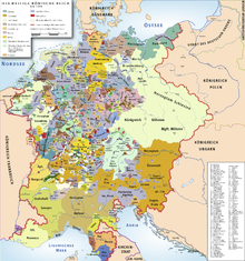
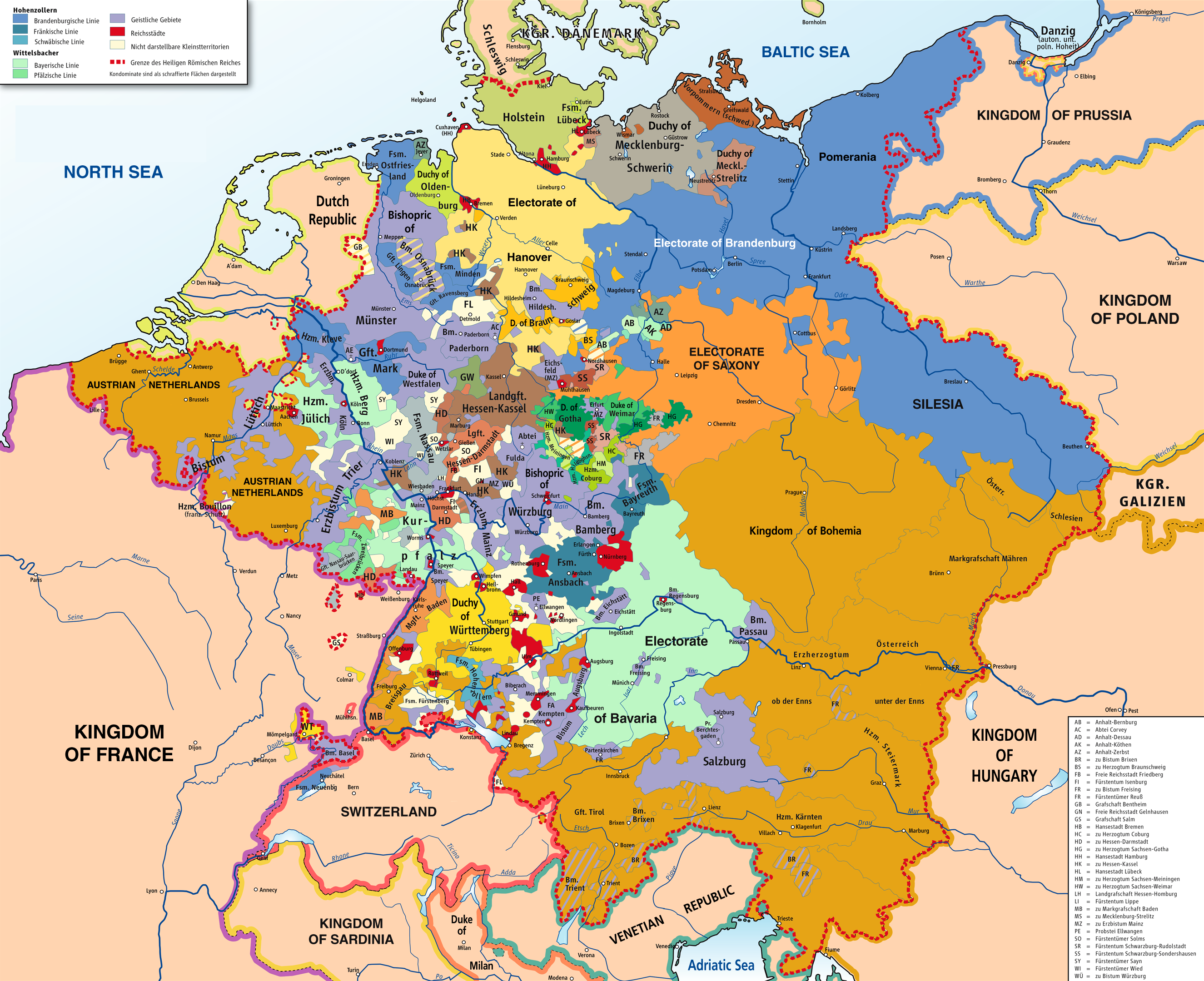
Updating Holy Roman Empire maps[edit]
Article: https://en.wikipedia.org/wiki/Holy_Roman_Empire
Requests: As fantastic as the https://commons.wikimedia.org/wiki/File:HRR_1400.png map is, is there any way to add some additional details to it? Within the Luxemburg, Wettin, and Habsburg lands, there are no internal borders between the different adjacent territories. As an example, I refer you to the https://upload.wikimedia.org/wikipedia/commons/4/4c/HRR_1789_EN.png where there are light gray borders between the Habsburg lands of Bohemia, Moravia, Syria, etc. I think this would help give a little additional detail. Additionally, this could help add some extra detail in a couple of other regions - I don't see the Bishopric of Verden within the Bishopric of Bremen; internal borders within Brunswik-Luneberg to clearly define the border with Brunswick-Wolfenbuttel as well as including the Principality of Luneberg (capital at Celle), and Principality of Grubenhagen; and also adding borders between the Bavarian divisions and Mecklenberg lands. You could even show some of the internal border regions in Savoy and Milan as those regions are large enough to show the detail. I would also like to see this detail inside Bohemia and Moravia and Selisia - beside just showing the borders between these two lands as I mentioned above, I would love to see some of the duchies and counties that existed in these lands as I can't ever find any maps that show this detail (maybe a good idea for a separate map as well). Additionally, in the countries that border the Holy Roman Empire, I like that they are just one color to differentiate the Holy Roman Empire but I would still like to see some gray borders in those countries of the duchies and counties around the Holy Roman Empire. I just love to see all that detail when I am reading articles to see what regions are next to what. Also, it would be nice if the menus could be updated to English but there is something I like about the entities being in German as it is their actual names. Maybe there is room to add a translation menu which at least explains the titles, ex. Gft. = County, Hzm. = Duchy, etc.). I also had one question about the Duchy of Teck (under the Margrave of Burgau). I have only ever been able to find this Duchy located on one map (http://www.lib.utexas.edu/maps/historical/shepherd/german2_shepherd.jpg) and they show it next to Ulm. I know there were two creations of the Duchy of Teck so not sure if this is where it was in 1400 and then there was a later Duchy of Teck by Ulm - just wanted to check for clarity.
As for the https://upload.wikimedia.org/wikipedia/commons/4/4c/HRR_1789_EN.png map, I would love to see it have the same resolution as the https://commons.wikimedia.org/wiki/File:HRR_1400.png map. There is a lot of detail on this map but at a greater resolution, you could add just a bit more. I would also like to see some of the internal borders in the Habsburg lands shown in the Electorate of Brandenburg and Electorate of Saxony, Electorate of Hanover, Austrian Netherlands, etc. And, any borders within France, Poland and Hungary would be great.
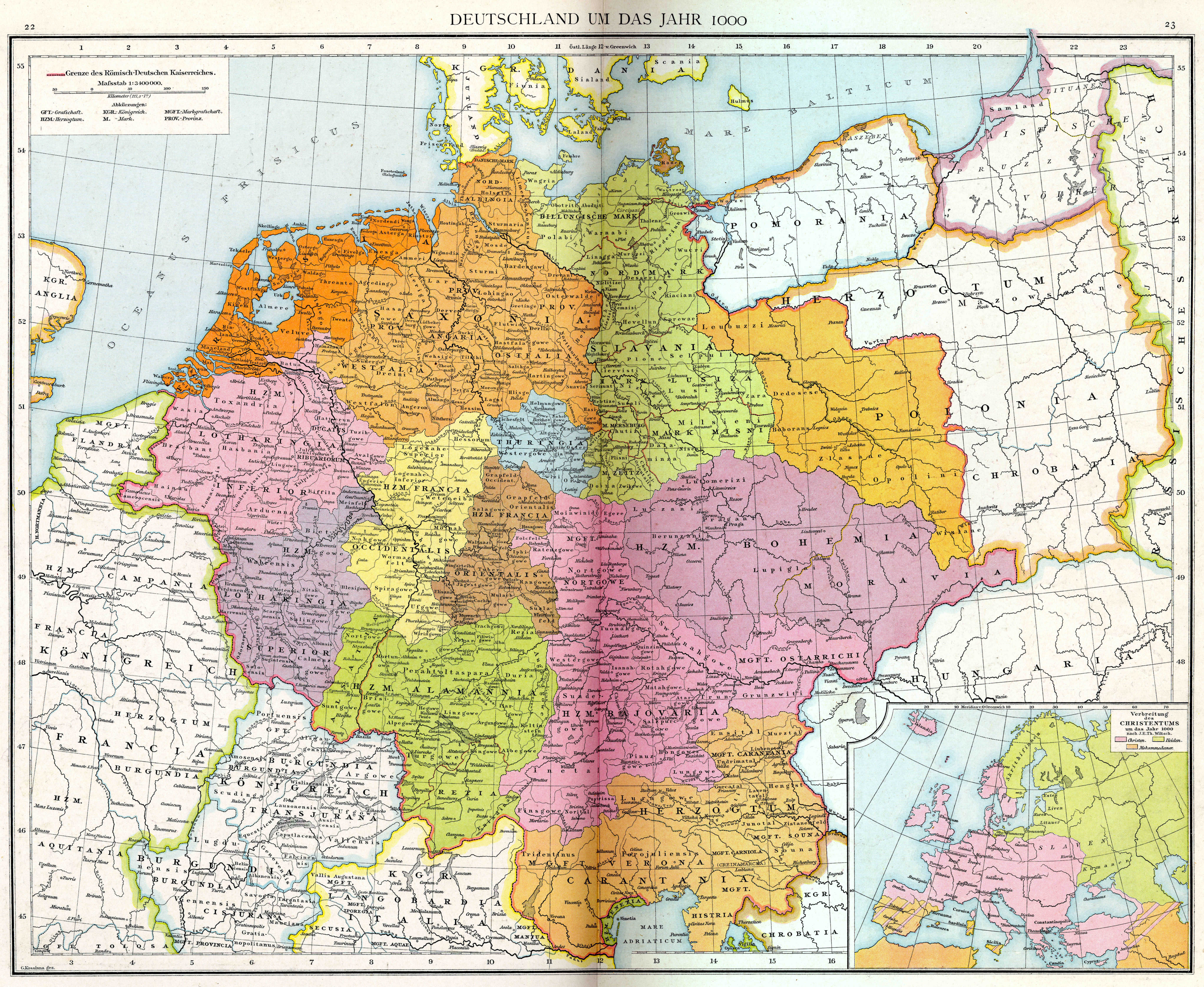
This has to be one of the best maps on Wiki of the early Holy Roman Empire from the year 1000: https://upload.wikimedia.org/wikipedia/commons/0/01/Droysens-22-23.jpg. What are the chances this would be updated to a modern map like the above at the same resolution as the https://commons.wikimedia.org/wiki/File:HRR_1400.png map and put in English? This map has so much detail that it would be a fantastic reference.
This is a great map of the Holy Roman Empire in 1689 (https://commons.wikimedia.org/wiki/File:Holy_Roman_Empire_1648.svg) but it needs to be updated to https://commons.wikimedia.org/wiki/File:HRR_1400.png level of resolution and detail.
Additionally, between this map from 1000 and the map from 1400, there are no other highly detailed maps of the Holy Roman Empire. I would love to see one from the 1200s to start off with at https://commons.wikimedia.org/wiki/File:HRR_1400.png resolution and level of detail which would give wiki a detailed map of the HRE every 200 years and then could eventually work on filling in the gaps to have one of the HRE every 100 years, e.g. 1296 when Duchy of Saxony is dissolved.
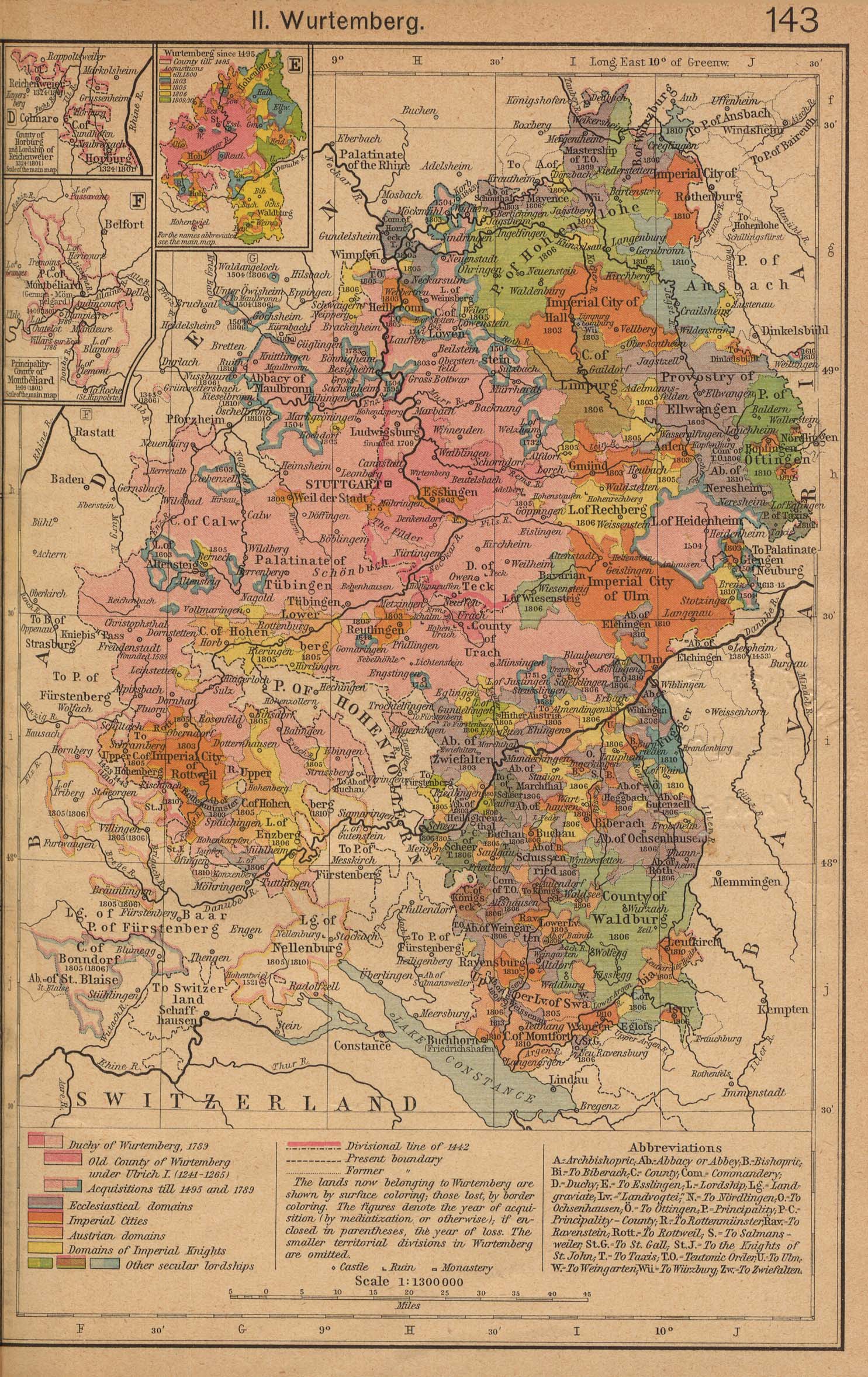
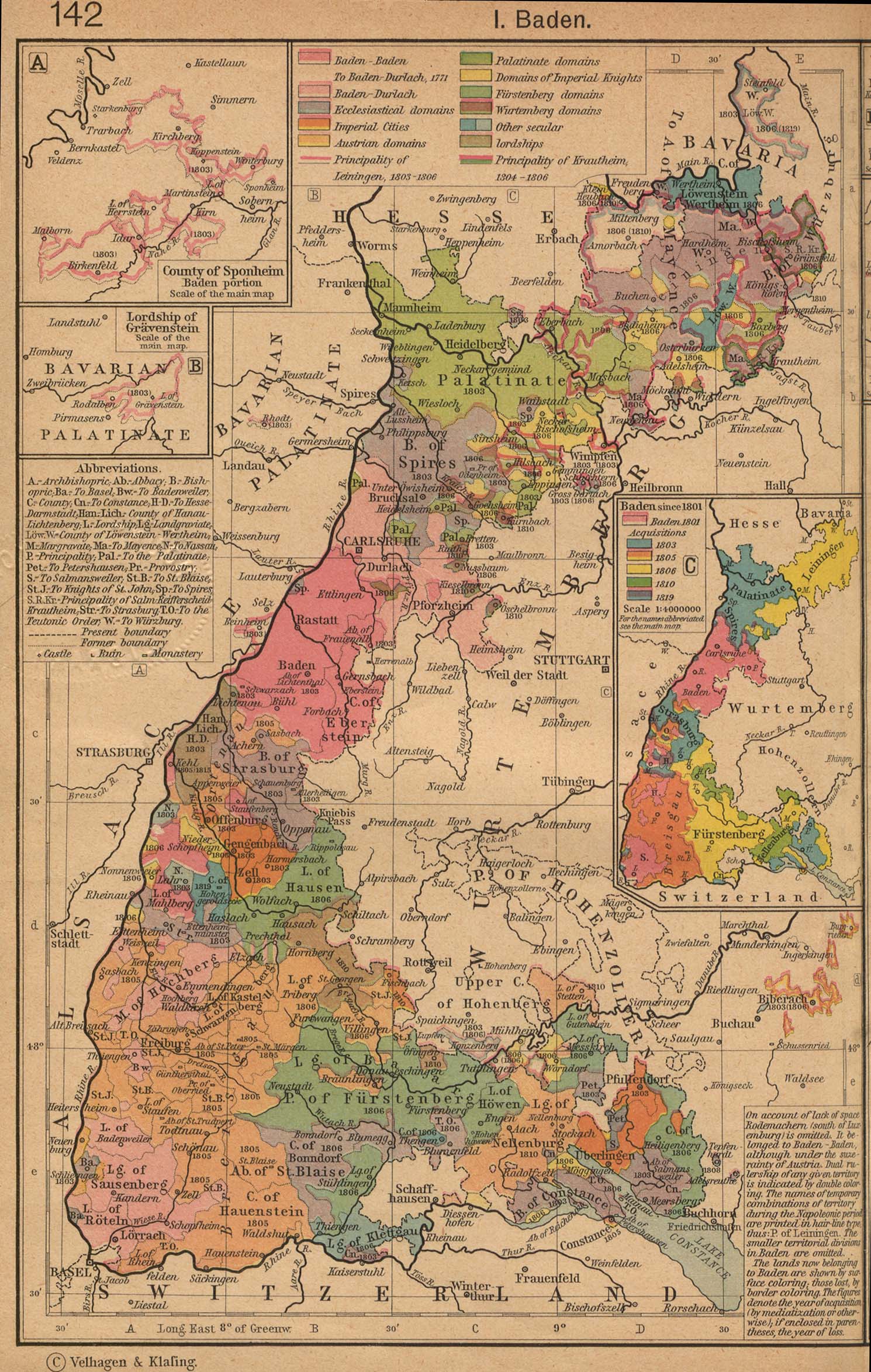
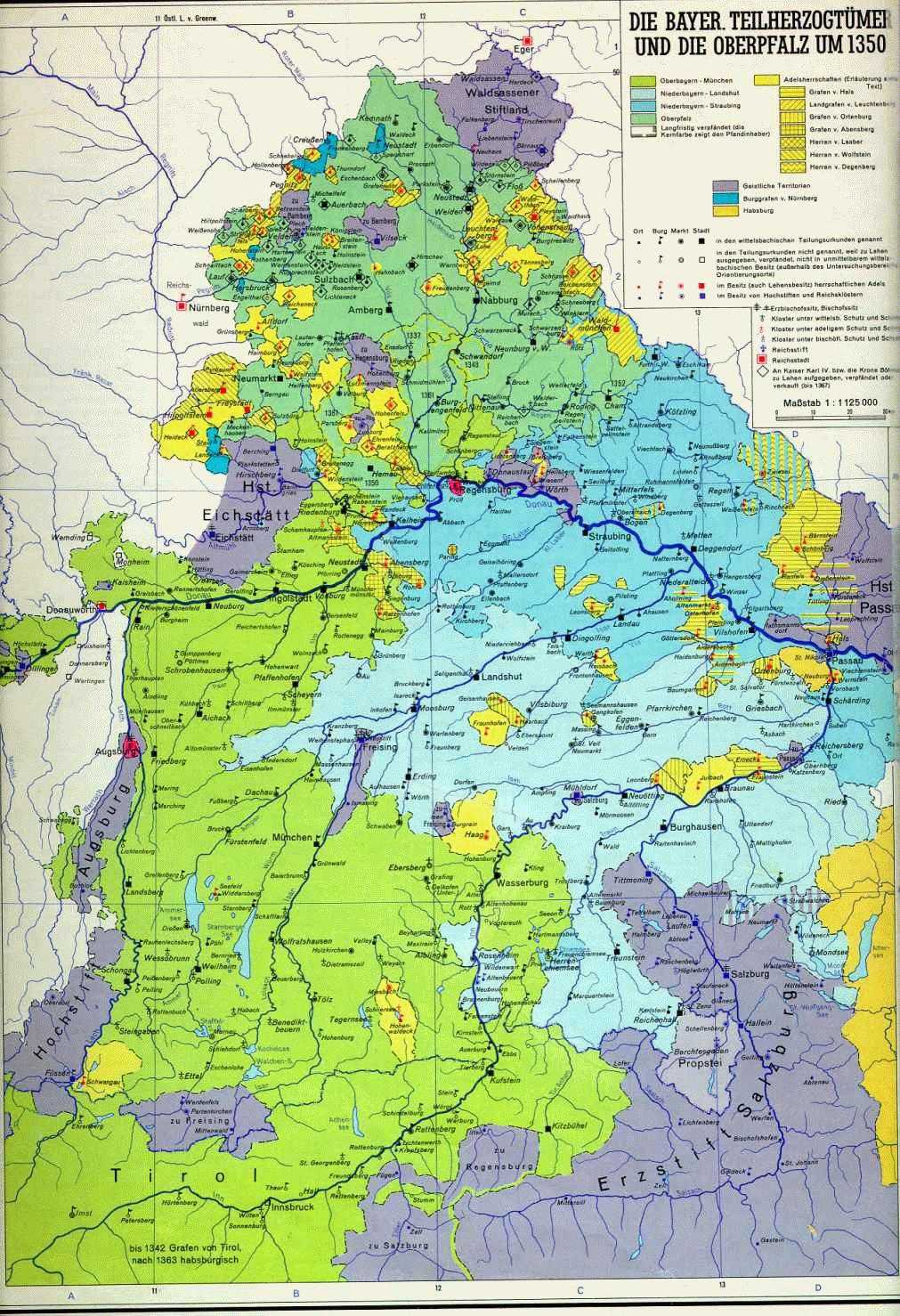
As for territories, I have found a couple of other maps I love to reference that I think would be great to update (obviously this is a long-running project): Duchy of Wurtemberg (http://www.lib.utexas.edu/maps/historical/shepherd/german2_shepherd.jpg). I think this map would be great to update as is but I would also like to see another map of just the growth of the Duchy of Wurtemberg up til 1789 as this map really shows the acquisition at the time of the dissolution of the Holy Roman Empire in the early 1800s but does not show how they acquired their main territories; Duchy of Baden (http://www.lib.utexas.edu/maps/historical/shepherd/german1_shepherd.jpg). I know there are some later ones that show the 1800s (https://en.wikipedia.org/wiki/Grand_Duchy_of_Baden#/media/File:Map_of_Baden_%281819-1945%29.png) but they do not have this detail. And again, it would be great to see an additional map with just the acquisitions up to 1771; Duchy of Bavaria (http://www.uni-regensburg.de/Fakultaeten/phil_Fak_III/Geschichte/1350g.jpg) this is a great map and I can't find anything like it on wiki. Bavaria is a great dynamic territory that should have some additional detailed maps from additional years; Electorate of Saxony: https://en.wikipedia.org/wiki/Electorate_of_Saxony#/media/File:Saxony_%28Division_of_Leipzig%29_-_NL.png and https://en.wikipedia.org/wiki/Electorate_of_Saxony#/media/File:Saxony_after_the_Capitulation_of_Wittenberg_%281547%29_-_NL.png need to be in English and the Ernestine branch of the Wettin dynasty maps (example as https://en.wikipedia.org/wiki/Saxe-Weimar#/media/File:SajoniaWeimar.jpg) should be updated and need one that includes all of the territories over several periods to show all of the divisions.
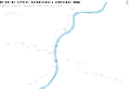
Scale is messed up[edit]
-
Map of Antarctica
-
Derivative map 1
-
Derivative map 2
-
Derivative map 3
-
Derivative map 4
- Article(s)
- Lots of articles in multiple Wikipedias
- Request
- "Map of Antarctica" originally had an accurate scale. However, in an edit of 19:58, 26 March 2008, someone switched the captions, making it depict 1000 miles as a distance much shorter than 1000 kilometres. Could you restore the original caption? It's not a matter of simple reversion, as someone's uploaded a revised version with various fixes (but still the broken scale) since then. The other four maps are derived from it, and all of them include the broken caption. --Nyttend (talk) 16:06, 10 November 2015 (UTC)
- Graphist opinion(s)
The derivatives have been corrected by Odysseus1479. The original generates a warning:
Upload warning Found href to unsafe data: URI target <image http://www.w3.org/1999/xlink:href="data:;base64,/9j/4aaqskzjrgabagaazabkaad/7aarrhvja3kaaqaeaaaahgaa/+4adkfkb2jlagtaaaaaaf/b aiqaeaslcwwleawmebcpdq8xgxqqebqbhxcxfxcxhx4xghoaghcehimljyujhi8vmzmvl0baqeba qebaqebaqebaqaerdw8rexevehivfbeuerqafbywfbomghocghommcmehh4eizarlicnjy4rntuw mdu1qea/qebaqebaqebaqeba/8aaeqgalwf5aweiaairaqmraf/eat8aaaefaqebaqebaaaaaaaa aamaaqiebqyhcakkcweaaqubaqebaqeaaaaaaaaaaqacawqfbgcicqoleaabbaedagqcbqcgcaud ddmbaairawqhejefqvfheyjxgtigfjghsuijjbvswwiznhkc0umhjzjt8ohxy3m1fqkygyzek1rk rckjddyx0lxizfkzhmptdepzrieupiw0lctu5psltcxv5fvwznaglqa2xtbm9jdhv2d3h5ent8fx 5/craaicaqiebamebqyhbwyfnqeaaheditesbefryxeiewuygzeuobfci8fs0fazjglhcoksq1mv y3m08sugfqkygwcmnclsrjnuoxdkrvu2dgxi8roew9n14/nglksftjxe1ot0pbxf1ex1vmz2hpam tsbw5vynn0dxz3ehl6e3x//aaawdaqaceqmrad8a9assssupjjjjskkkklkssssupjjjjskkkklk ssssupjjjjskkkklkssssupjjjjskkkklkssssupjjjjskkkklkssssupjjjjskkkklkssssupjj jjskkkklkssssupjjjjskkkklkssssupjjjjskkkklkssssupjjjjskkkklkssssupjjjjskkkkl kssssupjjjjskkkklkssssupjjjjskkkklkssssupjjjjskkkklkssssupjjjjskkkklkssssupj jjjskkkklkssssupjjjjskkkklkssssupjjjjskkkklkssssupjjjjskkkklkssssupjjjjskkkk lkssssupjjjjskkkklkssssupjjjjskkkklkssssupjjjjskkkklkssssupjjjjskkkklp8a/9k="> in the uploaded SVG file.
--Delphi234 (talk) 20:01, 29 February 2016 (UTC)
File:Antarctic fr.svg still needs to be fixed. Delphi234 (talk) 05:42, 4 July 2016 (UTC)
-
- Best guess is the error is generated because the base64 data is not properly defined i.e. for JPEG should be "data:image/jpeg;base64" and PNG should be "data:image/png;base64". There are 12 embedded images in the file, all 12 appear to be the same file, a JPEG. So if you correct these 12 with the correct JPEG identifier I listed above I believe it'll get you fixed up. Offnfopt(talk) 15:19, 4 July 2016 (UTC)
Malay and Chinese versions of MH17 maps[edit]
-
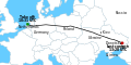
English map "MH17 map"
-

English map "Malaysia Airlines Flight 17 crash site"
-
.png/120px-MH17_Flight_Route_(en).png)
English map "MH17 Flight Route"
- Article(s)
- ms:Penerbangan 17 Penerbangan Malaysia
- Request
Please make a Malay version at File:MH17 map-ms.svg with this key from User:Cerevisae:
- Take off: 10:31 UTC - Waktu berlepas: 10:31 UTC (Waktu Semesta Berkoordinat)
- Netherlands - Belanda
- Germany - Jerman
- Poland - Poland
- Ukraine - Ukraine
- Russia - Rusia
- Donetsk - Donetsk
- Last contact: 13:20 UTC - Hubungan terakhir: 13:20 UTC (Waktu Semesta Berkoordinat)
- Crimea - Crimea
- Kiev - Kiev
Also please make Malay and Chinese versions of File:Malaysia Airlines Flight 17 crash site.png (Format is English - Malay/Chinese)
- route of Flight 17 - Laluan Penerbangan 17/17号航班飞行路线
- Donetsk - Donetsk/頓涅茨克
- Horlivka - Horlivka/戈尔洛夫卡
- Luhansk - Luhansk/卢甘斯克
- Area of missle launch - Kawasan pelancaran peluru berpandu/导弹发射区
- Russia - Rusia/俄罗斯
- Territory held by pro-Russian insurgents - Kawasan yang dipegang oleh pemberontak pro-Rusia/亲俄罗斯武装分子的领土
And File:MH17 Flight Route (en).png (Format is English - Malay/Chinese)
- Dnipropetrovsk - Dnipropetrovsk/第聂伯罗彼得罗夫斯克
- Donetsk - Donetsk/頓涅茨克
- Torez - Torez/多列士
- Hrabove - Hrabove/Hrabove村
- Russia - Rusia/俄罗斯
- 50km - 50km/50公里
- closed up to 26,000 ft - ruang udara ditutup sehingga ketinggian 26,000 kaki/空域关闭直到26,000英尺的高度
- closed up to 32,000 ft - ruang udara ditutup sehingga ketinggian 32,000 kaki/空域关闭直到32,000英尺的高度
--WhisperToMe (talk) 03:29, 3 December 2015 (UTC)
- Graphist opinion(s)
Improve Iceland outline[edit]
-
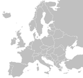
Blank Europe map
- Article(s)
- Allready in use.
- Request
- I would like to get the outline of Iceland fixed. The main issue I am having with this picture is the triangle in the western part of the country - it should be an peninsula, not an triangle. If you can, then please try to bring the outline of the country closer to the one present in File:Blank map of Europe cropped.svg. --Snaevar (talk) 16:12, 11 January 2016 (UTC)
- Graphist opinion(s)
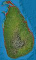
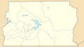
Location maps of Sri Lanka[edit]
-

(1)
Main location map -
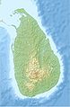
(2)
Main location map (relief) -

(3)
NASA topography map -
(4)
Custom-made to show Provinces. To be deleted.Google Earth borders are wrong. -

(5)
Custom-made to show Districts. To be deleted.Google Earth borders are wrong. Use this only for details on the northern borders. -
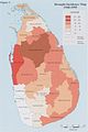
(6)
Scanned map from Survey Department to show accurate borders. To be deleted.
- Article(s)
- en:Template:Location map Sri Lanka
- en:Module:Location map/data/Sri Lanka Northern Province
- (more modules to be created)
- Request
- Replace the topography detail of the existing relief map (2nd file), with that of the more accurate and detailed NASA map (3rd file). (recolouring will be needed)
- Sharpen the provincial and district borders with those as shown on
files 4 and 5file 6. These two files are samples only, and are to be deleted. - Fix borders on the relief map (top area - 2nd file).
- Make provincial borders thicker than district borders.
- Remove the two rivers and reservoirs from the first two maps (see also), and
- If needed, you may visit this page to test the accuracy of the country's borders. The placemark's coordinates are very accurate (taken from Google Earth), and shows the extreme ends of the country. Thanks! Rehman 05:33, 25 March 2016 (UTC)
- Graphist opinion(s)
Sri Lanka adm location map.svg and Sri Lanka rel location map.svg are available now. NNW 21:20, 18 May 2016 (UTC)
- Thank you, NNW! Looks great! Just a few changes, would you be able to remove all the rivers and waterbodies from both new maps, and make the 2nd level (district) borders more lighter (lighter grey)? And instead of just trashing the river details which I just mentioned, would you be able to upload it to a completely new svg file using the topographic background, and including only rivers and 1st level/province borders, but no waterbodies. This will be very useful for the river articles which I am currently working on. Thank you so much for your help. Cheers, Rehman 01:30, 21 May 2016 (UTC)
- Deleting all lakes? Some rivers flow through lakes. Sri Lanka adm location map.svg and Sri Lanka rel location map.svg are showing only 1st level borders now, Sri Lanka adm-2 location map.svg and Sri Lanka rel-2 location map.svg 2nd level borders, too, with these borders with a thiner line. All these maps are part of a set of maps which all have to look the same. I can upload further files but they won't have file names related to location maps but you can use them as alternative maps for the template maps. NNW 16:58, 23 May 2016 (UTC)
@NNW: Sorry for the late reply. Please ignore my previous comment. Instead, would you be able to replace File:Sri Lanka location map.svg with File:Sri Lanka adm-2 location map.svg, but removing all the rivers while retaining the water bodies? This is because the current default map:
- does not have the waterbodies marked properly
- has no distinction between provinces and district borders
- and has less sharper borders when compared to the map you created.
Removal of rivers is because:
- the current map doesn't have rivers
- not all rivers are mapped
- having rivers will confuse viewers for borders, and looks too cluttered as well.
Similarly, the same applies to the relief maps (File:Sri Lanka relief location map.jpg and File:Sri Lanka rel location map.svg), but to add district borders as well. Please let me know if this is possible. Thank you, Rehman 14:00, 7 July 2016 (UTC)
Jasenovac concentracion camp map to SVG[edit]
-
IMAGE3.EXT
Description of third image (if needed; don't request too many at once, though)
- Article(s)
- en:Jasenovac concentracion camp
- Request
- It would be nice if this map can be converted to SVG that can be easily localised. The original photo is problably copyvio. -- Bojan Talk 08:13, 15 May 2016 (UTC)
- Graphist opinion(s)
Convert PNG map to SVG[edit]
-
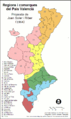
Png simple image
Article(s): Comarques del País Valencià and equivalent
- Request
- We need to convert this image into SVG --TaronjaSatsuma (talk) 11:37, 15 July 2016 (UTC)
- Graphist opinion(s)
Al Jawf location map[edit]
-
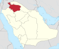
Al Jawf in Saudi Arabia
-

Required Map
-

uncolored version also
Article(s): location map in several articles on ar.wiki
- Request
- Can you please create a location map of Al Jawf region (red area) but on a background from the other photo. Thank you--باسم (talk) 19:53, 27 July 2016 (UTC)
- Graphist opinion(s)
Pakistan Sindh[edit]
-
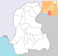
map of Sindh province
-
A location map
- Request
- hey, can someone:
- Graphist opinion(s)